

(main menu)
CAMPBELL
articles
CHARTS
menu
SITEMAP
site is
ABOUT
NEW

|
|
(main menu) |
CAMPBELL articles |
CHARTS menu |
|
SITEMAP |
site is ABOUT |
NEW |
|
additions and corrections will be noted in the appropriate place with a dated statement between { }, which can be searched for
Abstract
Before the magnetic compass was introduced into the Mediterranean in the 13th century how did mariners know where they were heading? The broad answer is that from time immemorial they had a so-called 'wind compass' in their heads. This divided the horizon conceptually between eight winds, each covering 45°. Those, in turn, would be notionally divided into half and quarter winds, with further subdivisions beyond that.
That much is well understood. However, when attempting to dig deeper it became apparent that not only has no contemporary explanation been uncovered, but neither were the recent interpretations plausible.
Lo compasso de navegare (c.1260-96), the most detailed of the early pilot books (known as portolani), contains nearly 1,300 instructions, using standard terms to describe direction and distance between paired points. In some instances, by dividing a half wind into eight, it offered a choice of high-resolution bearings with a precision of 2.8°.
How did the system work? A comprehensive analysis of Lo compassos statements had been carried out by Roel Nicolai and we agreed to collaborate in an attempt to reconstruct the medieval wind compasss subdivisions and their sequence. Difficulties abounded. Within any half wind there would be two one-eighth winds, but no way to distinguish them, nor did the frequencies of the eight named winds and the various subdivisions match statistical expectation. Because making sense of these uncertainties required interpretation, it was not surprising that Roel and I came to different conclusions on some points. For that reason, our schemas are described separately.
Nevertheless, the rigidly consistent language used in the directional formulations gives us a clear view, for the first time, of the full range of terms that must have been in oral use among Medieval mariners. Most importantly, the inclusion of some very precise terms must surely reflect actual navigational use at the time. Even if few pilots could have maintained a precision of around 3°, it must surely mean that some were attempting to do so. Why otherwise would that system which must have been widespread across the Mediterranean have been devised and disseminated?
If sailors held a mental chart in their heads – as an essay on the origin of the portolan chart contends – they could not have used that at sea without an attendant wind or astronomical compass.
Once a mariner had sailed far enough into the open sea so as to lose sight of land, he had to depend on astronomical clues or, lacking those, a compass, in order to identify and follow his planned direction, Until the magnetic needle became available in the 13th century, that meant the compass had to be a mental one. Usually termed a wind compass, since it loosely related to prevailing winds, this divided up the horizon into equidistant arcs.
Wind compasses, of varied types, must have been used from time immemorial, and almost everywhere. What differences would there have been in the direction-finding challenges facing a Phoenician sailor and a Mediterranean mariner in, say, 1150? Seneca, Strabo and Vitruvius, for example, were among the Classical writers who discussed it. Sampling JSTORs articles via a search for wind compass produced a number of instances, covering a wide geographical range: Mesoamerica (Aztec, Maya), Pacific (Carolines, Tahiti, Solomon Islands), Indonesia (Sulawesi, Bajo fishermen, Bugis Islands) and the Baltic (Åland Islands). No doubt navigators in other seas must have developed their own formal systems formal because it would need to have been systematised, memorised and shared with other navigators in that community, in the form of a common language.
The magnetic compass undoubtedly represented a major development because it provided, automatically and in all conditions, a single reference bearing (magnetic north) against which all others could then be calculated. In a comparable way, pilots wayfinding in the years before the introduction of the magnetic compass had to ascertain at least one direction, whether by using the sun, stars, the actual wind or any other indicator: perhaps a coastal or island feature, or indeed the sea itself. The mental compass would presumably have operated in a variety of ways: first, to confirm or adjust the bearing being followed at that time; second, to select a new course; and third, to identify a land-sighting by relating it to the ships heading, or vice versa.
That much is reasonable and necessary conjecture, in the absence of any contemporary account of the medieval wind compasss structure or how it would have operated in practice. That lacuna highlighted the need for a thorough and detailed investigation of this highly important, and largely ignored, element of medieval navigation. The aspect of particular concern here is the extent to which the scanty contemporary documentation is able to provide us with insights into the navigational practices in the medieval Mediterranean.
The wind compass in the 13th-century Mediterranean
Without precise directional information, and an appropriate format in which to express that via a widely shared
language, medieval mariners could not have operated safely in the open sea. The memorised details of the sequence
of wind directions must have been one of the major elements in the maritime lore developed by sailors across the
Mediterranean and beyond. If, as a 2021 essay on the origin of the portolan chart contends, 1
sailors held a mental chart in their heads, they must have had a wind or astronomical compass to accompany that.
What would have been the use to a pilot of a memorised picture of the interrelationship between the various capes
and islands around and ahead of him if he could not determine his own position?
Since the mental form of the chart and that of the wind compass were purely cognitive devices, neither would
have left any trace until the chart had been drawn out and the compass began to be documented textually in the 12th
or 13th centuries. Instead, as is discussed in detail below, we have had to deduce for ourselves how the
medieval wind compass might have been constructed and the way its subdivisions were labelled. Following a
discussion of the broad principles, there will be a more detailed examination of the two most significant of
the early hand-written sailing guides (the portolani), the Liber de existencia riveriarum, from
the early years of the 13th century, and Lo compasso de navegare from around its middle. A possible
contemporary of the latter in the Marciana Library in Venice will also be considered. From tentative re-creations of the wind systems that the authors of those portolani were
using, an attempt will be made to determine the degree of directional precision which navigators of the time might
have been able to attain. In the process, this may also give more confidence to future exercises by portolan-chart
historians needing to convert the portolani statements into approximate modern bearings, in the course of
assessing positional precision. After a long and necessarily detailed analysis, the discussion will broaden out into
an attempt to place the mental wind compass into its wider context.
In the first place, the term wind compass is misleading. The system undoubtedly reflected sailors knowledge of the winds likely
to be blowing from the various points, which explains why the eight or twelve main directions were labelled with
the names of the winds thought to be the most appropriate. But the essential word there is labels, since any
match would have been approximate. The helmsman would certainly have felt which way the wind was blowing
but he could not normally have used that to establish his heading, except in a very general way. [See an
18th-century anthropomorphic diagram of the 32 winds by Matthaeus Seutter.]
The real winds are too variable, in both frequency, seasonality and actual direction, to have been able to define a
disk of equal-interval arcs. Indeed, mariners would often have recognised the expected wind by its characteristics
rather than the direction from which it came (for example, whether it was hot or cold, wet or dry). The sirocco is
certainly very noticeable in southern Europe, since it can bring with it Saharan sand, humidity and high winds, but
its direction is not fixed nor is its presence wholly predictable. For practical navigation, the actual winds could
have served as no more than an unreliable mnemonic tool, and unreliability is the last thing needed in a navigation
instrument. Indeed the wind compass has one advantage over the magnetic compass that would replace it, since it
points to the broadly static Pole Star (without acknowledging that fact) rather than the shifting magnetic north.
The medieval wind compass must have been entirely pragmatic, providing sailors with a circular mental diagram of the
full 360° horizon, using standard names or phrases to identify the different directions. It had to be systematically
memorised and widely understood throughout the Mediterranean so that it could be used to follow a remembered
course or be orally shared with others.
To use the wind compass it would have been necessary to identify at least one direction. For example, one or other
of the cardinal directions (north, east, south and west) could have been estimated astronomically and the horizon
divided into quarters. It was then logical to add either one or two intervening divisions (winds) into those 90
degree arcs. The ancients used a mental compass comprised of either eight or twelve winds, which meant that the
angle covered by a single wind would be 45° in an 8-wind system or 30° in a 12-wind one. Confusingly, some of the
same names appear in both systems, thus giving different readings. For example, aquilo represents,
respectively, north-east (45°) in the 8-wind system and 30° in the 12-wind one, a considerable difference. 2 It was probably in the later Middle Ages that the classical eight-wind system, immortalised in the
Tower
of the Winds in Athens, was revived, becoming standardised and continuing thereafter for centuries. 3
It needs to be stressed that although the examination that follows uses numerical bearings, that is merely for
modern convenience. Three separate systems, in use then and later, need to be differentiated. The medieval
sailors sirocco would later be known as south-east, and can now be read off as 135° on the modern compass.
However, there was no concept of numbered degrees in the Middle Ages; the 360-degree compass, and indeed the
numerical system itself, were developments of later centuries.
4 The structure of the wind compass
The 45 degree spread of a full wind could never have served for actual navigation even if it might suffice for a passengers account of his voyage. Thus it is reasonable to suppose that the relative precision of half and quarter winds would have been needed, regardless of whether a system of eight or 12 winds was being used. Furthermore, it is evident that the medieval wind compass could accommodate more precise divisions beyond those. What seems to be the full range of expressions used to distinguish one wind subdirection from another has been unearthed as a result of this investigation although we have been left to speculate precisely what each term meant, and, crucially, their sequence in the imagined horizon circle.
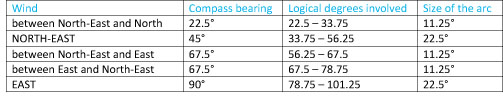
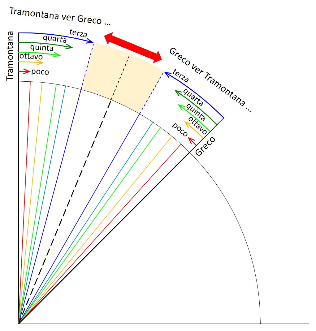
Besides selecting one of the eight named winds (e.g., tramontana, greco, levante, etc = north, north-east, east), or a pair of neighbouring winds considered together, a more precise direction could then be chosen. 5 In the wind compass, each named wind (spanning 45°) would be divided into two half-winds (22.5°), and then usually four quarter winds, thus arriving at a 32-point compass, each division of which spanned 11.25°. 6 Alternatively, once the half wind had been visualised, the more experienced pilot might be able to select one of its eight subdivisions, each no more than 2.8° in width. [See Figure 4.] That is how we might imagine it in action but there is no-one we can ask for corroboration. [It is hoped that these divisions will become clearer in the discussion that follows about recreating Lo compassos wind compass.]
It is easy to be confused by the two different meanings of the winds subdivisions. What is a half wind? The answer is that it could be one of two things: a line or an arc. As a line, it would represent the mid-point of the 45° wind, i.e. a bearing of precisely 22.5°. But it also indicates something quite different, namely one of the two segments of that wind, i.e. an arc with a width of 22.5°. It is in the latter sense that it was used in a wind compass. Where a modern magnetic compass can direct the mariner to a precise numerical bearing, the wind compass refers to spans. Hence, all wind compass instructions are, by their very nature, approximations.
When a half wind is named on its own (i.e. simply between Wind A and Wind B) it has to be understood as extending half way to the neighbouring division {see Figure 1: The major arcs of the wind compass). So the size of the arc referred to will depend on the complexity of the system being used at the time. In a 16-point system, which goes down no further than a half wind (i.e., the halves of the eight winds) the tolerance would be the full 22.5°, made up of half the distance to each of the full winds involved (twice 11.25°). In a 32-point system (as seen, incidentally, on the portolan charts), which introduces quarter winds, the range would be half as much (11.25° altogether), and so on for the 64-point and 128-point systems, as successive bisection doubled the theoretical precision each time (down to 5.6° and finally, 2.8°).
The Venetian galley officer and chartmaker, Andrea Bianco, draws out the wind subdivisions in his 1436 portolan atlas, following the 64-point system. 7 It needs to be appreciated that his diagram features two neighbouring winds, with the sequence running as follows: otava [one eighth], quarta [quarter-wind], otava [again], mezanin [the mid-point of the wind], otava, quarta, otava, vento [i.e. the end of that wind, and so on for the next wind]. 8 However, that is not a wind compass as such but rather an explanation of the compass line network seen on the portolan charts (with the addition of the one-eighth winds, which do not appear on Biancos charts or indeed others of the time).
By contrast, a functioning wind compass had to be able to distinguish between the two quarter and four one-eighth winds found in a single wind; Biancos labels cannot help there. This issue is at the heart of the discussion that follows about the explanatory language used in the wind compass, which needed to direct the pilot to a unique segment of the horizon.
The direction instructions used in the wind compass comprise a series of standard phrases. This would have been essential, both for memorising the full system and for conveying it orally to others. The surviving portolani, which reflect the same verbal formulae, are mostly in Italian, which may suggest that that was also the language of the wind compass used at sea. Being able to understand, remember, communicate to others, and follow those instructions must have formed one of the more important elements of a medieval pilots schooling.
A fresh analysis of the different approaches taken by the unknown authors of the Liber and Lo compasso in composing those statements reveals the scant attention that has been accorded by historians to that major component of those texts. No contemporary explanation of the language or use of the wind compass has yet come to light, and past attempts at decoding the abbreviated expressions were either incomplete or unconvincing.
It is worth remembering that whether or not the lost prototype portolan charts and the earliest survivors were constructed using a conceptual wind compass or observed magnetic bearings, the main directions continued long afterwards to be labelled on the charts with the names of the traditional winds. Until at least the mid-15th century (and indeed on Greek charts as late as the 17th) you can find in ornamented compass roses the initials for a number of the primary winds: G for Greco (north-east), S for Sirocco (south-east) and so on. 9
The Liber de existencia riveriarum [hereafter Liber] is the oldest surviving maritime guide for the Mediterranean, and dateable to the early 13th century. We know little about its anonymous author besides the fact that he had travelled widely and was connected in some way with Pisa Cathedral. He was a landsman, not a mariner, and wrote in Latin, as distinct from the Italian used for the second, slightly later text that will be discussed next, Lo compasso de navegare. In that case the author, again unnamed, was evidently a mariner, well-versed in maritime lore.
In attempting to envisage the cartographic information that the Libers author might have been using and how he interpreted it, examination of the so-called pelagic statements – the distance and direction between two places, usually involving open-sea sailing [on which see here] – provides important evidence, even if there are remaining uncertainties as to what some of it meant. 10
Most of those direction elements in the Libers statements refer to a single named wind (e.g. in sept[entrio] = head north), giving a precision no closer than 45°. Alternatively, two neighbouring winds would be paired with a single word, thus reducing the arc to a band of approximately 22.5° (because of the Propinquity PrincipleWhen two winds are mentioned, the half wind being referred to will be that which is closer to the first-named wind. These would be conveyed in a phrase such as: inter eur[us] et aust[er] (between south-east and south). 11 Where two winds were considered together, a range of link words was used: a, ab, ad, contra, ex, extra, fere, foras, infra, inter [or just in.], iuxta or versus. The great majority of the 196 instances isolated by Gautier Dalché are of the in. / inter forms [meaning follow Wind A, or head between Winds B & C]. The precise application of some of the other prepositions - most of which were noted only occasionally - is less obvious: a or ab (away from), ad (towards), fere (nearly) and iuxta (near) seem clear, but what about contra (opposite), ex (away from), extra (beyond), foras (outside?), infra (below, lower?), parum versus (turned a little towards)? 12 Unless some of the more rarely used among the dozen or so terms employed do indeed carry a specific meaning (even if this may not be clear to us) a few standard linking words would surely have sufficed to convey the basic meanings: 'away from, towards, between, beyond, a little, near'. It is worth emphasising the marked difference between the 12 prepositions used by the Libers author and the economical pair (enter and ver = between and towards) that sufficed for Lo compasso (as described later).
The following examples show some of the less usual forms found in the Liber:
The instances in this second group are at best ambiguous but in other cases clearly incorrect, or, as in the from north to south instances, include a tautologous second wind:
The first point that needed to be clarified was this: in a statement such as, between wind A and wind B, the second named
will sometimes come before and sometimes after the other in the circular sequence, whether that was clockwise or anti-clockwise.
13 From that, it was natural to assume that the first-named was always the closest, and was intended to be thus understood.
From that it further follows that in the statement A towards B the direction of travel is clockwise, whereas in B towards A
it is anti-clockwise. The further logical assumption is that the second half wind is a mirror-image of
the first, i.e., with the sequence reversed. Such a convention might seem obvious because, without that, how would it have been possible
to distinguish the subdivisions of one half wind from those occurring in the other? 14
Similarly, there are two quarter wind divisions in each wind; how would anyone have known which was being
referred to unless they had been clearly separated? That no statement has been found endorsing this
assumption might merely indicate the extent to which it was taken for granted. Konrad Kretschmers diagram
15
demonstrates the reversing of the wind names in the second half of the wind, without spelling out the principle
that the closest main wind was always mentioned first, any more than the Wikipedia
diagram does. Corroboration for the contention that what is being termed here the Propinquity Principle
must have been a standard practice can be found in the approximately equal frequency in the clockwise and
counter-clockwise mentions of each wind pairing in the Libers statements. Otherwise they would
presumably have followed a clockwise sequence throughout. 16 Following this principle had a
further advantage in that the creation of a solid wall in the middle of the wind provided a second boundary
line, in addition to the principal wind itself (as can be seen in Fig. 1 below). That half-wind boundary
line can be referred to equally as A & B or B & A. For some reason, Kretschmer chooses to cite the clockwise
or anti-clockwise versions at random in his diagram, which masks that important difference. However, not only has this principle not (seemingly) been endorsed, but following the lead
of Bacchisio Motzo, the 1947 editor of Lo compasso a different system has been proposed by some recent
authors, as will be discussed below. In light of the complexity and confusion of the directional terms found in the Liber,
we are bound to ask: did its author fully understand the system of divisions he was describing? Surely, all
that was needed in the statements involving two neighbouring winds was an indication of which one was closer to
the relevant bearing. So why did he use a panoply of terms to express what was surely a single observation:
that the desired direction lay between two winds and was nearer to the first cited? Since he moved in learned
circles in Pisa, might he have found repeating a standard formula tedious and, as most writers would be tempted
to do, decided to ring the changes? In that case the text itself does not explain how we should interpret the pelagic statements
perhaps because the reader was expected to be conversant with it – but maybe logic can help. On the
assumption that the author was using a coherent system, the following may be a sensible reconstruction. If I
have been pre-empted in this I am not aware of it. This example considers the suggested subdivision of the 45°
between north-east (aquilo) and east (oriens). It follows the principle that any reference to a
bearing has to be understood as extending either side of that line as far as half way to the two neighbouring
divisions involved (as was explained above: The
structure of the wind compass).
The directional statements are of two kinds. First, there are simple references to a single named wind. Because the quarter winds to either side of that had to be considered, this meant that the single-wind coverage was actually equivalent to the width of a full half-wind (22.5°). On the other hand, because the between statements come up against the fixed point of the half wind (as explained above), they could be restricted instead to a single quarter winds width (11.25°). Since the full-wind statements cover the same arc as the two half-wind ones combined, we would expect to see a similar frequency of each type in the Liber. In fact, the ratio is 3:1 in favour of the full wind. 17 The most obvious reason for that bias would be a natural rounding up to the simpler full wind expression and restricting the half-wind statements to those furthest away from the wind itself. We will see a similar patttern when Lo compassos directions are analysed (The erratic frequencies of the various terms). Despite that, the Libers author appreciated that refinement was possible below 11.25° because he sometimes adds a comment indicating closeness (fere, iuxta, parvum = 'near or a little). But that begs the question: why did he not supply that significant detail routinely since similar situations must have occurred frequently?
The issue of whether the Libers content was directed at landsmen or mariners comes into sharp focus in relation to these pelagic statements. Even assuming that the truncated formulae would have been understood by sailors, it is highly unlikely that they would have ever seen, or could have read, such a document, particularly as it was written in Latin. 18 Conversely, the specialist maritime language whether or not that was a reflection of what was common among seamen could have meant almost nothing to the literati.
In an important recent development it has been confirmed that the pelagic statements, in both the Liber and Lo compasso, must have been describing straight lines measured from a simple chart drawn over a wind compass. They were certainly not actual courses followed by pelagic sailors [on which see the 2021 essay ]. This means that, however restricted the maritime knowledge of the Libers author might have been, he must have received some instruction from mariners when devising those pelagic statements. Nevertheless, the unsystematic way that the prepositions were used confirms that he could not have been repeating verbatim (albeit in translation) the standard phrases used by pilots that had been passed on to him orally.
The coastal itineraries and the instructions for open-sea voyaging in the Mediterranean have rightly been studied for the light they shed on 13th-century understanding of the distance and direction between maritime termini, whether short hops along the coast or open water passages. As a result, it naturally followed that testing the precision of those statements has been the focus for such investigations.
By contrast, this section looks instead at the language used to describe the direction element of those instructions. It focuses primarily on Lo compasso de navegare [hereafter Lo compasso], the most extensive of the surviving portolano texts and one that introduced a further level of detail to that contained in the Liber. 19 Dated 1296 in the only extant exemplar, its original text is considered to belong to around the middle of that century. 19a
It was the works first editor, Bacchisio Motzo, who proposed in 1947 that a range of numerical terms included in those statements would have been used in the following fixed sequence: the wind name would be followed in each case by, respectively, un poco, octava, terça, quarta, quinta, octava, un poco. 20 This interpretation was followed by Patrick Gautier Dalché (1995) and Alessandra Debanne (2011). However none had attempted to explain how that shorthand might have worked in practice. Motzos summing up was cited thus by Debanne: Lautore del Compasso fornisce le direzioni sempre mediante questo sistema di suddivisione dellorizzone, senza dare spiegazioni. Questo fa pensare a un sistema largamente noto ai marinai, introdotto da tempo e divenuto abituale alla metà del secolo XIII [Lo compassos author always conveys this system of subdividing the horizon without giving an explanation. This suggests a system widely understood by mariners, which had been introduced some time earlier and had become habitual by the mid-13th century]. 21
As already mentioned in the context of the Liber, and confirmed by Motzo, there seems to be no contemporary translation into normal language of the precise meanings bound up in those cryptic expressions. Specifically, we have no earlier record of any equivalent use of those numerical terms (see The portolani in their broader context}, nor are they found, collectively, later. As Motzo had noted, no explanation is provided by Lo compasso itself; we have no descriptions of medieval navigation; and we look in vain for help from recent historians. 22 Instead, we have to fall back on what may or may not be an identical schema, revealed in the texts of the Liber and Lo compasso – supported by no more than logical deduction.
There are different possible interpretations of the abbreviated and partly coded language that was involved. Roel Nicolai explains the alternatives:
Firstly, it might be assumed that the system of progressively bisecting angles was continued beyond the quarter wind level. This leads to four equal intervals of a quarter-wind interval of 11.25° (or eight if you divide a half-wind angle of 22.5° and include the quarter wind). From here, there are two possible ways of numbering these intervals.
"Secondly, it might be assumed that these intermediate winds do not represent equal intervals resulting from progressive bisections, but were intended, as Kretschmer suggests, 25 to indicate a fraction of the half-wind interval of 22.5°. This is the assumption of my revised schema and this leaves this gap of a third of a wind (15°) in the middle (Figure 6). That sector is bisected straight away, because the half-wind sits in its middle, and bisecting each of the two angles thus created lands one with seven (not eight) uneven intervals, dividing up a half-wind interval. This interpretation is, although based on Kretschmers interpretation of tertia and quinta, not worked out to the full detail of the smallest intervals by him, but I did that and that leads to Figure 7.
"Thirdly, there is Tony Campbells interpretation that the numerical terms were treated as no more than convenient labels in a non-mathematical equal-interval system.
Roel Nicolai, 12 July 2020
While it was undeniably ingenious, Nicolais interpretation did throw up difficulties. For example, two of the subdivision terms, quinta and ottava, were effectively ignored by Lo compassos author (with just two instances apiece). In addition, ottava was presumed by Motzo to occur twice in each half wind, at the beginning and end of his theoretical sequence. But, since those instances would have been indistinguishable, it would have been impossible for anyone to tell which was being referred to. A wind compass constructed on that basis would have been unworkable.
Recently, Roel Nicolai agreed to run further analyses on his complete Excel database of the 1,287 direction statements in Lo compasso. Those are dispersed across a dense 120 pages in the version edited by Alessandra Debanne in 2011, and this is made more daunting by the repeated filling-in of abbreviations. However, once the Excel spreadsheet was extended to include individual sorted lists of each type of statement, a number of facts became clear for the first time. In addition to some unexpected findings, the comprehensive nature of the exercise carried out by Roel (where others had, not surprisingly, merely sampled) meant that a number of confident conclusions could now be reached.
I am personally most grateful to him for sharing his database. The additional unpublished information is the result of an arduous input of data, in which the directional statements have been isolated for the first time, and then analysed, both in statistical terms and through identification of the full range of textual variations. He has, working from a different route, accepted the Kretschmer interpretation of the four refining terms (terza, quarta, quinta, ottava) as fractions rather than sequential numbers. I had by then developed my own tentative schema, along similar lines, and we agreed to collaborate in an attempt to devise a joint solution to the outstanding problems.
There are four aspects to the arguments set out below:
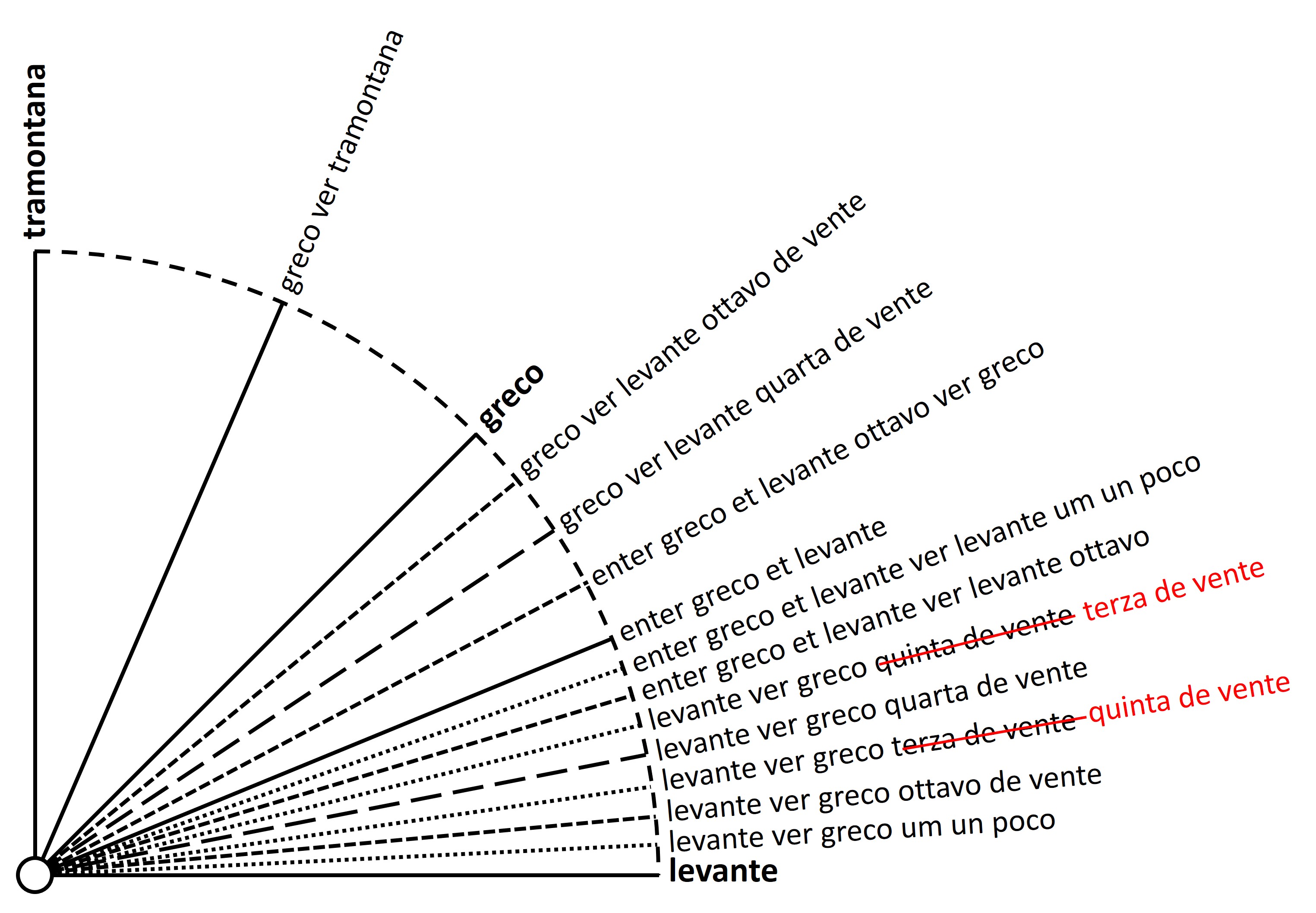
So, first, an examination of the precise language used for Lo compassos direction instructions. The first wind in a clockwise direction, that between north and north-east (tramontana and greco), will be used as illustration throughout. Because each of the eight winds would have been subdivided identically, these examples can stand in for all the others, even though some of their subdivisions are not explicitly recorded in Lo compasso.
Some of the directions (whose relative frequencies are discussed below) mention no more than a single wind, e.g. per tramontana (sail north). Others will pair two neighbouring winds without further comment, e.g. entre tramontana e greco (sail between north and north-east). Another expression, tramontana ver greco (literally north towards north-east), found frequently in Lo compasso, may have had the same meaning. The syntax of that last phrase would then be built upon to produce the following forms, (apparently) indicating alternative fractions: a third, a quarter, a fifth, one eighth, and finally a little:
Beyond that it becomes more complicated and difficult to interpret. The following are examples of directions found in Lo compasso that include plui, i.e. more. They appear no more than 18 times (representing just 1.4 % of the total) but their formulation is standardised. Had there been examples for our two winds they would have been in one or other of the following variant forms, presumably pointing, respectively, back towards the first wind, and onwards towards the second one:
All of the examples above start with tramontana and thus, according to the Propinquity PrincipleWhen two winds are mentioned, the half wind being referred to will be that which is closer to the first-named wind, which names the closer wind first would refer to the first half of the 45° full wind. It is being assumed here that the other half wind would be a mirror-image of the first, with all the instructions starting instead with greco. So in attempting to reconstruct the language and sequence of the medieval wind compass we need be concerned only with the 22.5° band of a single half wind, which could then be universally applied. The questions that have to be answered are these: how were those segments of the horizon systematically divided up – i.e., into how many subdivisions – and in what sequence?
As has already been stated, it seems that Lo compasso (the most elaborate of the surviving texts) includes most, if not all, the distinct expressions used in the medieval wind compass. However, piecing it all together is a bit like doing a jigsaw puzzle without the guiding picture, or playing an obviously complicated game without the instructions. So, before embarking on that difficult task, certain assumptions have to be made and declared.
At the risk of some repetition, the following seem, logically, to be the main requirements, based on what I contend can safely be considered as unchanging needs:
Overall, the system had to be simple, clear and unambiguous; misunderstandings could have had serious financial or safety implications. The general assumptions above would be deemed to apply to any system, not just Lo compassos. But in this case, apparently faced with more instructions than there were places to put them, there was an additional assumption: that each expression (leaving aside a handful of aberrant exceptions) should be incorporated into the schema, even if, to achieve that, it might be necessary to accept that at least two of the frequently-cited expressions were synonymous and thus pointed to the same subdivision.
Lo compasso has 1,287 usable statements. They break down into the following types
and are here treated (for illustration) as fractions rather than numerals
|
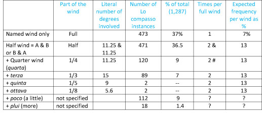
+ Indicates that these are suffixes to joint-wind statements e.g. tramontana ver greco
quarta & There is only one half wind in a full wind, but this is counted twice here because the half-wind line generates two descriptions, one for either side of it # There are four quarter winds in a full wind but what is counted here is the single line dividing a half wind |
In actual sailing conditions both the expressions and the wind names must have been used with equal frequency, as stated above. However, when comparing the real and expected instances, it is immediately evident that Lo compassos text cannot be giving us either a full or a consistent picture of the oral wind compass being described. This applies both to the number of times a particular formulation occurs and to the uneven citing of the names of the individual winds.
The expected frequency column in the table above would give different results depending on the premise adopted. It has been assumed there that the larger a given span, the more frequently it would be encountered (and likewise cited when used at sea). On that basis, instead of the roughly 20% expected for the combined total of full and half-wind expressions, those actually occur almost three-quarters of the time in Lo compasso. Conversely, the quarter wind (the next level down) of which two are present in each wind, features less than would be expected – a comment which applies also to the most precise directions.
From that it is evident that Lo compassos author was not systematically working to the most detailed level indicated by the terms he was using, even though he does demonstrate a knowledge of more finely-tuned directions than the 11.25° of the quarter wind. As a result, there are no more than 223 (17%) instances of non-standard winds (i.e., those other than full, half and quarter) which, statistically, should have collectively formed the majority. Might the disproportionate number of statements involving just a single wind or a full half wind indicate an understandable tendency to round up to the nearest main division, as has already been suggested in the case of the Liber (see The Libers wind statements)?
In reality, there could be no difference between the winds or (ideally) the subdivisions of each.
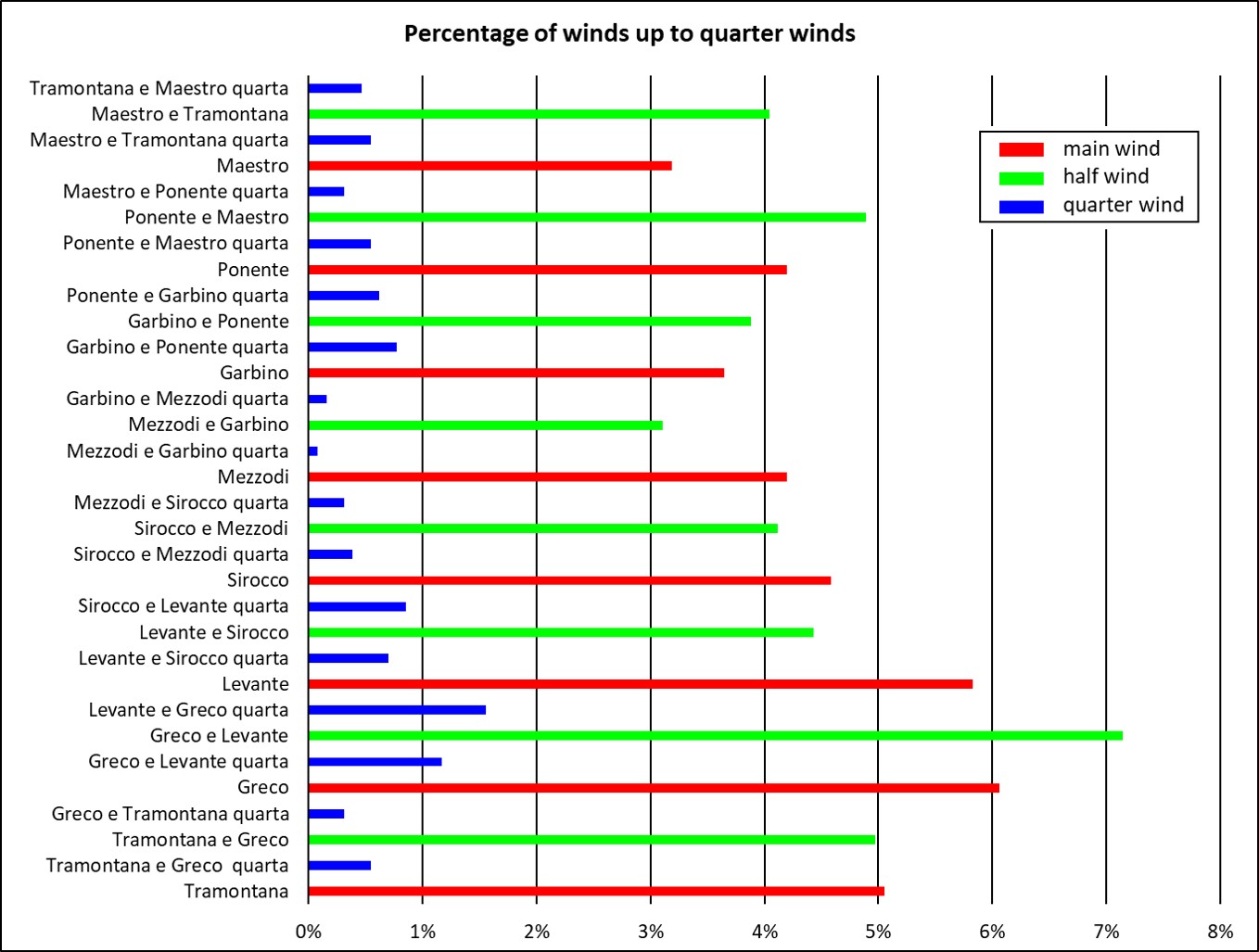
Furthermore, Roels detailed analysis above showed notable variation when related to the mentions of the individual wind as well. Why are there only 41 citations of maestro (north-west) but almost twice as many (78) for greco (north-east)? Similarly, when the 120 instances of quarta are matched to their individual wind, the frequency varies from 0.1% to 1.6% of the total. For the half winds the range is between 3.1% and 7.1%. No explanation for those discrepancies is being offered here.
Before moving to a discussion of the meaning of the directional instructions themselves we need to try and envisage how the medieval pilot would have divided up the sea in front of him, and how fundamentally that would have differed from our own perceptions and practices.
It needs to be remembered that the 32-point compass (as found on the portolan charts) lists no more than four subdivisions of a wind. Sticking to our usual examples, these would read (translated into their modern equivalents): north, north by east, north north-east, north-east by north, north-east, representing the half and quarter winds, with 11.25° divisions between them. The little-used 64-point compass (with 5.8° divisions) would start, in that same example: north, north half east, north by east, etc. Finally, with a 128- point compass (each unit 2.8°), it becomes even more complicated: north, north quarter east, north half east, north three-quarters east, north by east, etc.
Although the division of the horizon into 360 degrees had been used by the mathematicians of ancient Greece, that device has no place in a discussion of the medieval wind compass. The measurements in degrees in this section of the essay have been given in that way simply to aid modern understanding; they would have been meaningless to the medieval sailor, just as he would not have thought in terms of 16-points, 32-points, etc. Furthermore, the system extracted from Lo compasso did not deal exclusively with repeated bisections (half, quarter and eighth), since its schema was a hybrid one, including other terms as well (third, fifth and plui / poco).
As will be shown, difficulties remain when it comes to recreating the medieval wind compass, but it seems likely that the schema it describes goes two levels beyond the quarter winds (each of 11.25°), by including eight subdivisions of each half wind. In other words this is apparently a 128-point system. If so, any user who needed more precision than the quarter wind must have made a conscious decision to leave behind the system of bisections and change gear so as to select (or respond to) a list of (probably) eight terms which identify the very precise subdivisions of a single half wind. This would mean that the most detailed instructions were not just an extension of the more generalised ones but, to some extent, alternatives to them. The pilot working to a 32-point system would need to identify the relevant wind, divide it and select the appropriate half wind, and then divide that in turn to arrive at the desired quarter wind. The more experienced mariner, on the other hand, would have stopped at the chosen half wind and then jumped three levels (from 22.5° to 2.8°) to reach the point where one of the eight most exact terms could be chosen.
Why a schema for defining direction at sea in the Middle Ages should have apparently been so elaborate is a
challenging question. If correctly understood, it would have been comparable to the fully worked out 128-
point system introduced, it seems, in the later 18th century or perhaps a little before, and designed to be read off
a compass card without requiring verbal identification (see an inconclusive Wikipedia discussion from 2014
about when the 128-point system was introduced and a brightly-coloured illustration of an example elaborated with
lettering).
Any attempt to re-construct the wind compass partly demonstrated to us in the text of
Lo compasso is faced with two separate problems. First, what is the correct sequence of terza, quarta, quinta? Should it be in that numerical order, or reversed to reflect the growing number
of degrees indicated by those terms if they are interpreted as fractions of a wind? Second, what is the
meaning of the other composite expressions? Third, are we sure that there were eight subdivisions of a half
wind, as seems to be generally assumed [on what evidence?], or might there have been six divisions, or some
other number?
On the basis that we have to find a space for each type of expression in the projected schema, the following
seems to be the full list, with their literal meanings. It is assumed that these would need to be applied
to the first half of our sample wind (north heading clockwise towards north-east), with the sequence reversed for the
second half wind which started at greco (north-east) and proceeding counter-clockwise back to north.
Those expressions ending terza, quarta and ottavo occasionally have a further suffix,
de vento, i.e. of the wind.
In the first place, eight divisions of a
half wind requires nine identifying names not eight (as itemised later) so as to include both ends. The
list above comprises ten expressions. One difficulty, which might reduce the total of relevant expressions
to nine, concerns the respective meanings of this pair:
How should we understand the difference between those two formulations? At face value, each can be interpreted as a
general reference to the half wind as a whole. Since the mid-point is already occupied by quarta,
these terms presumably refer to the half-wind line itself. Yet each of the two forms occurs
frequently and, as confirmed in Roels analysis, with rigid discipline. Any suggestion that they have the same meaning runs counter to the almost verbatim formulations for
all the other instructions. This is perhaps the largest of the loose ends (but see Roel on this below in Revised wind schema).
The most elusive expressions, in terms of their position in the wind compass, are the last two in the full list above,
those including one or both of the words poco and plui (a little' / 'more). In the case of
poco alone, there are 112 instances in Lo compasso and of plui (with or without
poco) no more than 18 (representing just 1.4 % of the total). This contrasts with the results of a
search in the online version of the 1909 work by Kretschmer, which found a
number of examples of piu in 15th-century portolani but only 25 for poco (see further
in The portolani in their broader context).
However, those are not aberrations because, significantly, they are also found in another 13th-century
portolano, preserved in the Biblioteca Marciana in Venice.
26
The important point for our purposes is that, in contrast to Lo compasso, the Marciana text otherwise
adheres strictly to a 16-point system, without even quarta, let alone terza, quinta or
ottavo.
In 2012, David Jacoby described another portolano, extending to 81 folios, now preserved in the James
Ford Bell Library of the University of Minnesota, Minneapolis, which covers the entire Mediterranean, the
Adriatic, a section of the Atlantic coast of Morocco, and a section of the Black Sea. 27 Jacoby argues that the 15th-century Italian text reproduced a 13th-century original, with a number of
significant additions. In some respects it was more detailed than Lo compasso. Since, not
surprisingly, Jacoby did not specifically mention the wind directions nor were examples of the nautical
instructions given, it cannot be considered in this discussion. It is hoped that Jacobys call for a full
edition will be heeded.
By contrast with the James Ford Bells MS, the Marcianas text is just a fragment of a portolano,
containing no more than 20 references to a single wind and six to paired winds. However, in addition to
those, it also includes six examples of the poco or plui forms. 28 These appear in the original text in this order:
When arranged by expression type, with A indicating that the first named wind comes before the other in the
clockwise sequence, the Marciana formulations can be classified as follows:
Even if, in Lo compasso, the equivalent expressions might have been interpreted as markers for two specific
subdivisions, it is hard to see how that could apply to the Marciana, which does not, apparently,
include any other directions of comparable detail. Instead, those expressions might be better understood as
relating to the non-stated quarter wind (quarta). Because all those statements include ver
(towards), the absence of the quarter wind (quarta) seems to suggest that their function might simply
be to direct attention to one or other side of the point where that line would have been envisaged. On
that basis, the first three of the terms immediately above, which identify two winds only, might point to
the near side of where the quarter wind would be, and the fifth and sixth [the 4th is clearly an error] to
the far side of that line.
29
However, if there is a difference in meaning between 'A and a little towards B' and, as it might have
been in the complete original work, 'A and B and a little towards B', it is not obvious to me.
A similar logic might be tentatively applied to the equivalent expressions in Lo compasso:
What subdivisions are likely to have been needed for a wind compass
and how might that have worked in practice?
The underlying principles involved need to be understood before the likely sequence for Lo compassos subdivisions can be sensibly considered. The most basic unresolved issues are these:
Should Kretschmer be followed in seeing terza as one third of a wind (15°), or
instead Motzos interpretation that terza represents the third subdivision in a sequence of eight
(2.8°)? Perhaps, as will be argued shortly, those terms should not be interpreted mathematically or
numerically at all.
Is there general agreement about the list of conjectured requirements stated earlier, which it seems
logical a mariner would have needed from a wind compass? (see Analysis of the terms used in Lo compassos wind compass)
It also needs to be recognised that the building blocks of Lo compassos system are of at least three types:
As far down as the level that is being termed the 3rd (that of the quarter wind, i.e. 11.25°), the number of divisions doubled with each bisection, but no further. When trying to fit the other expressions into a half-wind sequence a different logic must have applied.
Since, the ottavo line – as one-eighth, the final bisection occurs twice in each half wind, how could both instances have been accommodated? If that had been required, it would have been possible for them to have been differentiated with a suffix. But that did not happen. So, if only one instance could be used, what was its function and where would it have been placed: early in the sequence or late? Leaving aside the uncertainties surrounding the other numerical terms, where would the little / a little more instances have been placed if the system was made up entirely of equal intervals?
Speculating about what the devisers of the wind compass might have done does have relevance, because since what has been suggested would have been obvious steps the fact that they chose to ignore those possibilities gives us some insight into their thinking.
For example, the 3rd, 4th, 5th and 8th terms already included could have been completed by using all the numbers between 1 and 8. That would surely have been the simplest solution (for those today at least). The fact that they did not do that shows that they were thinking in a different way. Might the mixture of terms of different types, a hybrid, have created variety, which would have been easier to memorise? A possible answer – which might solve many of the difficulties in understanding the medieval wind compass – would be that, rather than trying to interpret literally those terms that were not the result of bisection, and would thus have failed to provide the necessary equal-interval arcs, we should instead move away from numerical figures altogether. All the expressions would then be treated as little more than labels: in other words, as convenient mnemonic devices, ignoring mathematics. That interpretation mirrors the non-literal treatment of the wind names themselves (but see Roel Nicolais wind schema for a contrary view).
If that were the case, by divorcing terms like terza and quinta from their literal meaning as fractions of a full wind, this would have avoided the uneven divisions that would have otherwise occurred. As labels in a purely theoretical schema they could have evenly filled the gap on either side of the quarter wind, regardless of the precise bearings we might now read into them. The users would have known there was a fixed number of options either side of the quarter wind and they could have loosely gauged which one seemed the most relevant at that moment.
The syntax for the poco and plui expressions, respectively, is different in Lo compasso. For instance, poco always starts with a wind name and plui with entre. Because of that they should probably be treated differently. Since tramontana ver greco poco, differs only in the last word from the terza, quarta, quinta, ottavo expressions, it might seem logical for those poco instances, at least, to have been included in the formal subdivisions, as minor refinements.
However, it may not be appropriate to assign the cumbersome plui terms to specific positions in the sequence of subdivisions. It is considered that Lo compasso, whose original text is thought to date to around the middle of the 13th century, may contain (in ways not yet recognised) information that was added between then and 1296, the date stated in the sole surviving text. Perhaps the plui instances, whose equivalents in the simplified schema of the Marciana portolano were described above (Interpretation of the directional instructions) had a different, generalised purpose. Alternatively, they might have been additions by a different editor, using a reduced schema. Certainly, their inclusion in any reconstruction of the wind compass is problematic.
Given their cumbersome, non-intuitive wording (which could surely have been simplified), and the obscurity of any literal translation, it is possible that the plui instances in particular, and indeed the wind compass in general, might have been intentionally intended to convey an aura of mystery to the passengers who saw or heard it in use. In other words it may have been treated like a trade secret. But the evidential silence could also be put down to the fact that specialist artisans in the medieval period rarely documented their working procedures. And later practitioners perhaps took those so much for granted they did not feel the need to explain. This would apply equally to the wind compass and the detailed route knowledge required for pelagic sailing, both of which existed orally but were not routinely written down.
Beyond that, there is the general point that portolan-chart investigations need to avoid any bias in favour of the printed record, for instance by rating text more highly as apparent evidence than the necessarily speculative (and inevitably un-evidenced) oral practices that must have lain behind any writing anyway. Lacking textual assistance, it is on the oral and mental aspects that our focus must concentrate instead.
The following is a tentative re-creation of the medieval wind compass, based on evidence that has come to us without explanation. It is conceivable that during training (or perhaps to show a passenger) a wind disc would have been drawn out, conceivably on sailcloth or some other material. If that ever happened no examples have yet been recognised, and it has to be wondered if such a diagram would have helped an illiterate apprentice, since the names or expressions would have had to be written down. It is probably safe to assume that the wind compass remained, at least throughout the Middle Ages, a purely mental and oral affair. 30
The only evidence we have comes from Lo compassos statements and even if those are not necessarily complete, and they have certainly not been used consistently we have to find a sensible slot for each of the formulations. Some expressions, if found at all elsewhere, are rare, and if there are occasional instances in later portolani those have not yet been investigated in the thorough way that Roel Nicolai has done for Lo compasso. [However see The portolani in their broader context.]
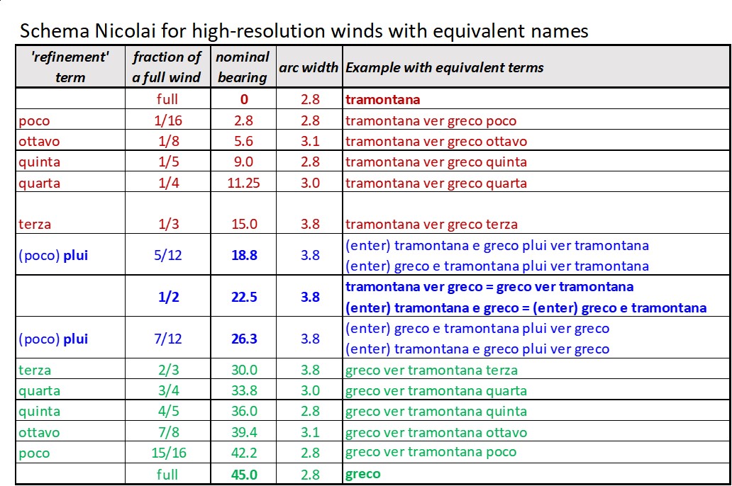
Motzos 1947 schema for a half wind had included two instances of ottavo and two of the poco expression. Since those pairs could not have been differentiated, it is assumed in the very provisional schema below that only a single instance of each should be included. We cannot be sure whether those occurred towards the beginning or the end of the sequence but all mariners using the system would undoubtedly have memorised the expressions in their correct order. Nor can we be sure whether the sequence would have followed the order terza, quarta, quinta or the other way round.
Given that we have been trying to find a place in a half wind for nine named lines, with eight arcs between them, it might seem perverse to suggest that the medieval wind compass could, in practice, have comprised just six of the most precise arcs. But is there any clear evidence that it had to be eight? Whether six or eight, we can be sure that quarta would mark the half-way point of the half wind. For a system with eight subdivisions there would therefore need to be three terms before quarta and three afterwards; for six subdivisions there would be just two terms on either side. If the two plui formulations were removed from the list, on the grounds that they belonged instead to a simplified system - of the kind demonstrated in the Marciana portolano – that would bring the schema suggested below down to a six-term one. If that was the case, the average length of a subdivision in a sequence of six would be 3.75° compared to the 2.8° for eight subdivisions. Less precision would make more sense, and give a marginally more realistic interpretation of the likely navigational abilities of the time. As already stated, there seems to be no explicit evidence in support of an 8-division arrangement, besides the word ottava, which, as suggested before, might merely have been a label rather than one of the two one-eighth winds. [Remember there is no mention of first, second, sixth, or seventh divisions, which weakens any literal interpretation of ottava.] Six or eight subdivisions is just one of the possibilities permitted by the elusive evidence.
The attempted reconstruction that follows deals with the two half winds (demonstrating a strict application of the Propinquity PrincipleWhen two winds are mentioned, the half wind being referred to will be that which is closer to the first-named wind), working clockwise from north to north-east. It also assumes that the second half wind (beyond the dashed line) is essentially a mirror image of the first, i.e. reversed.
--------------------------------------------------------------------
Although Roel and I concur that neither the Kretschmer nor Motzo schema is complete or convincing, the very tentative sequence above has been challenged by Roel Nicolai. Despite using the same data derived from his own detailed analysis we have started with some different assumptions, leading to contrasting conclusions. I have therefore invited him to contribute his own interpretations and the reasons for those.
Towards the end of 2019 Tony Campbell approached me, challenging the interpretation of the fine divisions of the wind rose in Lo compasso de Navegare as published in my PhD thesis and subsequent book. 31 The divisions up to the quarter wind are not disputed: a quarter wind is halfway between a main and a half wind. However, no guidelines exist on how to interpret the division into finer, intermediate directions.
The principle behind the medieval wind rose used in the Mediterranean is the halving of the angles of 45° between the eight main winds to sixteen winds and then again to the level of quarter winds (11¼°). My initial assumption was that this progressive bisection would have been applied twice more to obtain finer subdivisions, resulting in eight equal angular intervals of 2.8° wide (one-fourth of an interval of 11¼°). The finest level of bisections is shown in the 22½°-wide sector immediately above levante (i.e. towards greco) in the diagram below, which, to my dismay, proved to contain an error, which will be explained below.
Campbell challenged my equal-interval division of the sector of 22½°, arguing that:
As a result, I embarked on a (rather feverish!) inventory and analysis of the use of these terms in the Compasso. The key statistics resulting from that analysis are mentioned in Campbells text above. Regarding the first point above, I quickly discovered that in the whole of the Compasso or rather in the 17% of the courses for which these high-resolution winds had been used the term ottavo (de vento) occurred only twice and in both cases it concerned a refinement or correction to a main wind and not to a half wind. I had created the ottavo de vente refinement adjacent to the half wind (enter greco et levante ver levante ottavo) only in order to create eight intervals of 2.8° each.
The formulation enter greco e levante [refinement term] poco, ottavo, quinta, quarta or terza: correction to make to a main wind in order to obtain an intermediate wind occurs only in the Compasso with [refinement term] = (poco) plui, so I concluded now that there were no grounds to assume the [refinement term] could represent an ottavo de vente. With one of them removed from the interval of 22½° between a main and a half wind, any potential confusion between two ottavos in that interval had thus become a moot point.
Tony also convinced me that his second point was correct, because the naming of these intermediate winds did not make sense if the names represented ordinal numbers; they would be out of sequence, with the ottavo de vente being in the place where one would expect something like secondo de vente, a term that does not exist in the Compasso. Moreover, the sixth and seventh intermediate winds in an ordinal sequence would be missing and the eighth (ottavo) would have created nine intervals instead of eight.
After reinterpreting the intermediate winds as fractions, with terza representing 15° and quinta 9°, I redid my numerical analysis of these winds in the Compasso and found, to my surprise, a maximum deviation of only 0.9° with my old analysis, completed in 2009. I had apparently used the intermediate winds in the right sequence, but had evened out the differences between them, creating equal intervals. The diagram above therefore contains a painful error: the locations of the terza de vente and quinta de vente had been swapped. Fortunately, the analysis of these intermediate winds, high-resolution winds as I called them, did not suffer: the correction of 0.9° in some of them is hardly noticeable.
Based on a reinterpretation of the terms indicating high-resolution winds (i.e. finer than a quarter wind) as fractions and the actual occurrences of formulations in the Compasso I have come to the following revision, using the 45° interval between tramontana and greco as an example. Rather than dividing the interval of 22½° between a main wind and a half wind into eight equal intervals, the new schema I propose creates seven unequal intervals.
 Red intermediate winds: refinement term operates on the first main wind (tramontana) Blue intermediate winds: refinement term operates on the half wind (tramontana ver greco) Green intermediate winds: refinement term operates on the second main wind (greco) |
In principle, the formulation structure of a high-resolution or intermediate wind is as follows:
[main wind 1] ver [main wind 2] [refinement term]
[refinement term] = poco, ottavo, quinta, quarta or terza
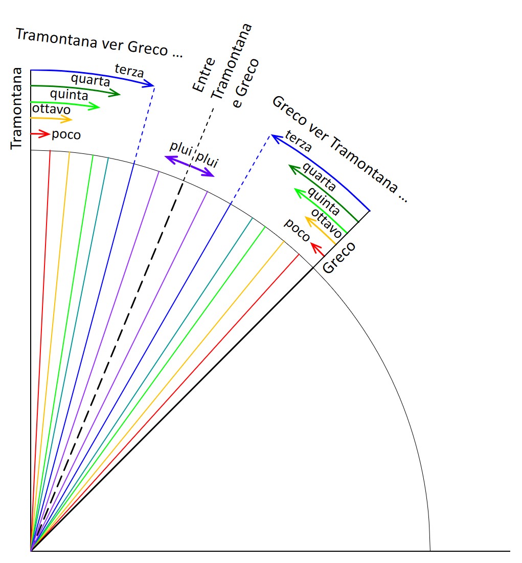
The terminology in the Compasso is quite consistent, as Tony already remarked; 205 of the 223 occurrences of the intermediate or high-resolution winds (i.e. finer than a quarter wind) adhere to this structure. However, the revised wind schema presented so far only covers two thirds of the 45°-wide sector between two main winds; the middle third cannot be described, because the next fraction down from a terza (one-third) would be one-second, or half, and that would describe the half wind. The not-covered part of the sector is indicated below in yellow.
The sector can either be left as it is, which is unsatisfactory, as it is makes the unequal intervals even more unequal. Ideally two more intermediate winds would have to be created in the yellow zone, one on either side of the half wind indicated by the dashed line. Therefore, these intermediate winds can only be described as a refinement to the half wind while all others are described as refinements to one of the two main winds. In the example above, the half wind would be designated by the formula enter tramontana e greco or enter greco e tramontana, followed by the words ver tramontana or ver greco, depending on the direction in which the refinement term poco, ottavo, quinta, quarta or terza: correction to make to a main wind in order to obtain an intermediate wind should be applied. The alternative term tramontana ver greco for the half wind would be unusable, as it would lead to twice using the word ver in the designation of the new intermediate wind, which might have been confusing, e.g. tramontana ver greco plui ver greco. The latter formulation does not occur in the Compasso.
The full formulation structure found in the Compasso is as follows:
enter [main wind 1] e [main wind 2] (poco) plui ver [main wind 1 or 2]
There is no indication as to the meaning of the word plui or of how large the associated correction is; a reasonable guess would be that the interval is divided in two equal halves. The term plui occurs 18 times in the Compasso, of which three times are in combination with the term poco (poco plui), which I have treated as alternative, but identical to just plui. This completes the schema as follows.
It is stressed that, although well-defined directions are used in the diagram above, the medieval concept of
wind would have covered an arc of the horizon. Therefore, all directions that would lie in the arc spanned
by the middle of one interval to the middle of the adjacent interval would be covered by the relevant
intermediate wind separating these two intervals.
Supplementary remarks on Nicolais revised schema
The key difference between my revised schema and Tony Campbells is the Propinquity PrincipleWhen two winds are mentioned, the half wind being referred to will be that which is closer to the first-named wind, which he adopts as the primary principle in the interpretation of the formulations in the Compasso. This principle plays no role in my schema. The Propinquity Principle creates a fundamental difference in the interpretation of the formulation enter tramontana e greco (poco) plui ver tramontana. In my revised schema the term enter tramontana e greco is interpreted as the half wind between tramontana and greco. In Tonys schema the refinement term of poco plui occurs twice in any 22½°- sector between a main wind and a half wind; once adjacent to the main wind and once adjacent to the half wind, thus creating seven intermediate winds (i.e. eight intervals), whereas my schema has six intermediate winds (seven intervals) in that 22½°-sector. In both schemas these intervals are unequal.
A few more things may be said about my schema: the sequence of fractions: 1/16, 1/8, 1/5, 1/4, 1/3 and 5/12, associated with poco, ottavo, quinta, quarta, terza and (poco) plui respectively, is a good approximation of an equal-interval series, as the diagram above shows. I am convinced this indicates that this sequence was designed, rather than having emerged spontaneously in a milieu of seamen. What is remarkable about this sequence of fractions is that the fractions one-sixth and one-seventh are conspicuously missing; they do not feature at all in the Compasso. It requires a mathematically gifted person to come up with such a sequence and, given the period in which this presumably took shape, the name of Campanus de Novara (c.1220-1296) springs to mind. 32 Campanus is best known for his translation of Euclids Elements into Latin. It should be noted that in the Middle Ages, arithmetic worked with fractions; the modern decimal notation of 2.82° was unknown. The inspiration for this sequence of fractions, if this reasoning is correct, might have come from Pythagorean music theory, which formed part of the medieval quadrivium. This divides the tone interval of one octave into fractions that are quite similar, though not identical, to the above sequence. It may be said that the sequence of fractions used for the intermediate winds is a good approximation of these Pythagorean intervals.
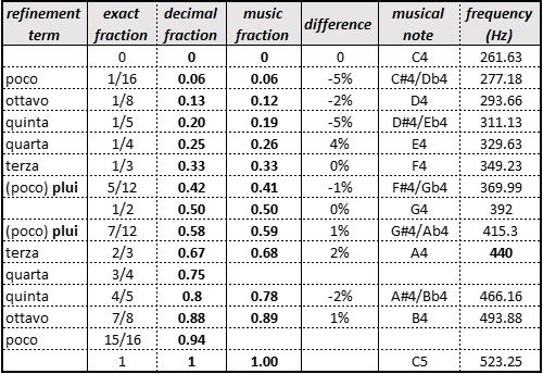
Whether or not this similarity is coincidental, the fact remains that the sequence of fractions used for the intermediate winds is a pretty good approximation of an equal-interval sequence.
An open question is still why the percentage of high-resolution bearings is so low: 223 out of 1287, or 17%. Tony Campbell comments on that too. I am inclined to agree with James E. Kelley Jr.s interpretation. Kelley observed that the percentage of such non-standard bearings as he calls them drops steadily in later portolans and virtually disappears at the end of the fifteenth century. His interpretation is that these high-resolution directions were too fine-grained to be practicable. 33
Because it has recently become clear that the numerical data in the Compasso de Navegare has been scaled from a (portolan or pre-portolan) chart (Nicolai 2014, A critical review , p 347 – see endnote 31), including these high-resolution directions, the option presents itself that the high-resolution bearings were scaled off with the idea to help mariners with their navigation. Although well-intentioned, its practical implications would probably not have been grasped. This may account for the low percentage of such bearings in the Compasso: a well-intentioned attempt to help, but impractical and prematurely abandoned. If this were the case, it would be reminiscent of the Portuguese mathematician Pedro Nunes, who issued instructions for periodic tiny course corrections to keep the ship on a great-circle course instead of letting it run along a rhumb line on a constant course. This too was well-intentioned but utterly impractical and therefore never implemented.
Roel Nicolai, January 26, 2020
The reasons for our different interpretations may well reflect our backgrounds: Roels as a scientist and mine as a historian. That might help explain why his schema has an overtly mathematical dimension, and indeed origin, whereas mine is grounded on assumptions about the needs of practical seamanship, which would have required a pragmatic way to divide up the horizon into equal-interval segments, expressed in a logical sequence for mental use and oral transmission. In that scenario, no mathematical knowledge or thought would have been involved, and the terms used, like the wind names themselves, no more than convenient labels. Even if the system we are dealing with emerged, say, in the 13th century, I would argue that it was likely to have been a revised, perhaps extended version, of what had been used for millennia.
The two of us have different levels of confidence in our own schemas. Roels sequence of subdivisions is neat and complete, and bolstered with logical argument, even if the lack of hard evidence means that it cannot be fully corroborated. My own tentative attempt does little more than suggest a possible sequence. It suffers from unease about a system that jumps from the third level (a quarter wind of 11.25°) to a surprisingly precise group of 2.8° subdivisions, effectively ignoring the fourth level of the one-eighth wind (5.6°). How could what are essentially two distinct systems have co-existed: repeated bisections on the one hand and a choice of (probably) eight very fine bearings on the other?
I can see valid reasons for terza and quinta occurring in that numerical order but, equally, as fractions (although not as parts of a 360° system). Nor am I at all sure that the poco plui instances form part of the same system or that there had to be eight rather than, say, six subdivisions of a half wind.
The one point on which I am confident is what I have termed the Propinquity PrincipleWhen two winds are mentioned, the half wind being referred to will be that which is closer to the first-named wind, the firm rule that whichever wind name is given first in a two-wind statement must have been the closer one. Given that some of the terms are repeated within a single wind, and that the terminology does not use suffixes to differentiate between those instances, the propinquity principle seems to be the obvious way they would have avoided confusion. For that reason, I cannot support the two instances in Roels schema where that rule is set aside (at the half-wind line). Even if there is no documentary evidence for that principle, there is no sign that it was ignored. On the contrary, I contend that it must have been universally understood and one of the first things that needed to be explained to a novice.
Ideally our collaboration would have arrived at an agreed interpretation. Part of the reason it has not happened may be because of the uncertain status of our major shared source, Lo compasso. Who was or were its author(s)? Where did the formalised expressions come from? How well were those understood by the author(s)? What connection did the scaling-off operation from a chart have with the navigational practice of the time? Why are any precise bearings given at all since so few were cited at that level? Maybe documentary evidence will emerge one day to help answer those questions.
To the extent that we can trust Lo compasso, which is our only real guide, it means that, thanks to Roels perseverance, we now know the language that medieval sailors were using. But we are still left to the mercy of speculation as to how those statements were bound together into a single coherent system. This lack of unanimity provides an opportunity for others to comment or suggest alternative solutions. Both Roel and I would welcome reasoned interventions.
Lo compasso occupies a significant historical position. It was preceded by less elaborate Latin models and may have been roughly contemporary with the other early Italian example (in the Marciana Library in Venice). It was to be imitated by Marino Sanudo (c.1318-20) 34 and subsequently followed, particularly from the 15th century, by a large number of others. The 13th century seems to have been an important period for the development of such sailing guides.
That the 15th-century portolano in the James Ford Bell Library of the University of Minnesota (discussed by David Jacoby in 2012 and discussed earlier: Interpretation of the directional instructions) was based on a 13th-century original demonstrates how early texts could be regularly, if unsystematically, updated. This confirms that, even if elements were added or details altered, the format and language of the portolani seems to have remained broadly static.
Those wishing to sample some later portolani, helpfully transcribed by Konrad Kretschmer in 1909 (pp.246-552, see Note 6), can now take advantage of a scanned version, placed online by Harvard University. 35 Since it is possible to search for any word and enlarge the retrieved page, the opportunity was taken to look for citings of the less usual direction terms. The results were as follows:
This confirms the rarity of terms more precise than quarta. Because its directions occasionally extended beyond that third level, Lo compasso seems to have been without parallel, since, as Kelley suggested, the later portolani stripped out the finer subdivisions. 36 Nor did the portolan charts themselves offer directions down to the fourth and fifth levels (5.6° and 2.8°). Pietro Roselli, around 1450, doubled to 32 the number of directions radiating from the centre of the network (from the Carte Pisane onwards there had been 16) but, since no extra intersection points were provided, the number of usable directions – formed by connecting each intersection with all the others – remained at 32. 37
Moving forward in time, it seems that it was not until the 18th century that the 32-point system was extended by using half- and quarter-points to give a total of 128 directions. Certainly printed portolani, at least as late as 1726, continued to express directions in terms of the medieval wind compass (on which see further How the portolani reflect the wind compass; and Endnote 45).
If we are to stand a chance of recreating the medieval sailors mental wind compass we surely need to consider the unchanging requirement of pilots when looking at the terms used by Lo compassos author. This is where the purposes of a written pilot guide and a navigational chart need to be distinguished. The author, for example, is assumed to have been describing the 32 directions he would have found on some kind of a marine chart from which he was copying. But, by presenting them in the form of a simple direction/distance statement, he was ignoring the reality of longer pelagic voyages, which would almost certainly have involved a number of intermediate landings perhaps for supplies and water requiring various changes of direction. In addition, each course was described in a portolano in one direction only. For a galley that might have been of less concern, but the different winds involved when going and returning would often have imposed alternative routes on a sailing vessel.
It also seems surprising that, of the Libers 196 pelagic statements, Gautier Dalché found only 68 repeated among Lo compassos list of 1,287. 38 This lack of overlap between the two portolani confirms what is revealed by a comparison of their respective toponymic lists, namely that the two compilations used markedly different sources.
It is also relevant to point out that if the pelagic information had been transmitted only in writing it would almost certainly have been full of dangerous mistakes. Errors and omissions have been noted in the pelagic statements in both the Liber and Lo compasso. 39 That is no more than would be expected since the information a scribe was copying would probably lie outside his experience and hence be meaningless, particularly the mileage figures. To the pelagic pilot, however, correct memorisation of the direction and distance component of an open-sea course could be crucial.
It is not known why Lo compassos author added the extra precision of fourth-(?) or fifth-level refinements, and then only in a small number of instances. But since the exercise in which he was engaged was a theoretical one, not directly related to actual pelagic courses, we can be sure that directional precision was not his major concern. Any more than it was for the portolano written by the sailor turned chartmaker, Grazioso Benincasa, in 1435-45. The distance instructions in that work are no more elaborate than the norm. On the other hand, he may have been responsible for introducing the numerous soundings he records (e.g. XIII pie daqua [13 feet of water]). 40 Because those details could not be shown at the scale of the portolan charts, that information would have been of considerable relevance for inshore pilots.
Nevertheless, the practical value of a portolano for the practising navigator should not be overstated. Because the so-called pelagic information in the texts will have been copied from a chart, it is hard to see how a navigator would have found much useful supplementary information there. We also learn from Ramon Pujades that such volumes were found only rarely in the inventories of sailors who had died abroad. 41 The Liber, for example, has come down to us, not on its own but as a separate unit of 16 folios, preserved with three other unrelated texts in a bound volume.
Until the 15th century, the number of extant portolani is very small; indeed, in the 14th century we have more portolan charts than portolan texts. 42
Despite the fact that of the two early portolani which have been studied in detail, one, the Liber, is written in Latin and the other, Lo compasso, in Italian, and that there are recognisable differences in the construction of their respective directional formulae, the underlying elements, including the assumed Propinquity PrincipleWhen two winds are mentioned, the half wind being referred to will be that which is closer to the first-named wind seem to have been broadly the same. Regardless of the fact that the refinements found in Lo compasso go well beyond the 32-point system of the quarter winds, whereas the Libers expressions had been largely restricted to the 16-point limit of the half wind, there is no valid reason for supposing that they do not reflect the same mental wind compass of practising sailors.
That assumption seems to have been shared with James E. Kelley, even if not specifically stated by him. Evidently not yet aware of the Liber, he observed that there is a tendency in the earlier portolani to express bearings with somewhat greater precision than 32-points He went on to say that, as the manufacture of magnetic compasses improved, and as their use became more widespread, there was probably a realization that neither the charts nor navigational practice were precise enough to warrant the extra precision carried up to that time. 43 So we are in agreement that there was presumably a single complex wind compass, which could be used by the portolani authors in full or in slimmed-down versions, and we also concur that the most complete instances are found in the 13th and 14th centuries. But I part company with Kelley about the likely reasons for the later simplification. As explained in the previous section, I have urged that a clear distinction needs to be made between the content of the portolani texts and the probably unrelated shipboard practices. The likely editorial biases of the two texts under discussion should also be recognised.
Considering the length of time it must have taken, first to develop and then promulgate, a wind system to the sailors of many nations who plied their trade across the Mediterranean and Black Seas, it seems highly unlikely that there would have been rival schemas, either at the same time or afterwards. Once fully developed, we would expect the wind compass expressions to have remained broadly unaltered. Indeed, we need to ask the question, who would have been in a position to change such a widely distributed mental system, given the general conservativism of sailors?
Underlying my own explanation for the medieval wind compass (and one that differs from Roel Nicolais) is the premise that it would have been devised by sailors and disseminated by them. It would not have become a shared language if it had been imposed from outside. The same applies to the portolan charts, whose source is identified (in a 2021 essay) as deriving from the long-held mental maps of open-sea Mediterranean pilots. 44 The long-delayed introduction after 1569 of the Mercator Projection into marine charts – for which it was specifically intended – demonstrates the wide gap between theory and practical action, as likewise that of the generally-ignored Pedro Nunes, cited earlier by Roel Nicolai.
The wind compass must have been orally transmitted from an experienced mariner to a novice, almost certainly by means of regular recitations of the successive divisions until it was firmly fixed in the boys memory. This would have been akin to the way that the sequence of the points of the magnetic compass were cemented by the boxing the compass routine of later centuries. Although, given the fundamental differences between the eight and twelve wind systems, and the supposed revival of the eight-wind version in the later Middle Ages, it is unlikely that we are seeing a direct reflection of one specific ancient system. 45
What we can derive with some confidence from those two early texts is that the respective authors must have used the directional system they had memorised in order to extract the details from a cartographic document, translating those into formal expressions. It is highly probable that the standard phrases employed by the two authors reflected those in use by the sailors of the time presumably including Lo compassos author himself. But, in conveying the basic elements of the directional lingua franca, that text is not necessarily showing us the limits of the oral system or how it was used in practice.
When studying Lo compassos statements, the portolan-chart historian is trying to look beyond those in an attempt to glimpse the memorised, orally-transmitted system from which they derive. There can have been no other source, since, even if Lo compasso had a textual antecedent, the same conclusion would apply to that. The thoroughness and clarity with which that text was examined by Roel Nicolai means that, for the first time, we have a complete picture of the directional information set out in what is the most detailed of the surviving early portolani. Despite that, while the facts are now transparent, we are struggling to understand how they fit together and what all of it means.
In particular, are we justified in assuming that the very selective use made of the most precise of the directional instructions by Lo compassos author tells us only about him, and not about the general usage of the oral wind compass that would have been employed at sea? Lo compasso, like later portolani, was, to a large extent, using a generalised system. This was composed, primarily, of full and half winds, along with some, but not many, third level quarta instances, and then, beyond that, a selection of five other terms, totalling in all no more than 17% of the overall expressions. But, despite the fact that some of those more-narrowly-focused terms are occasionally found in other portolani, 46 there is another indicator that may help to provide assurance that Lo compassos text does genuinely reflect the language and usage of sailors.
Although there is erratic frequency in the citing of the different directional expressions, it is important to emphasise the authors tight control over the phrasing of those instructions. For example, the great majority are of the form Wind A towards Wind B, followed, when appropriate, by a defining term (terza, quarta, quinta, ottavo, poco/pauco). Leaving aside a small number of irregular (perhaps mistranscribed) instances, there are just two exceptions to that invariable format: first, what may be an alternative expression used to describe 40% of the half wind statements (between Wind A and Wind B) and, second, the extension of that same wording found on a small group of plui [more] instances. Significantly, it is the format where the all-important message is conveyed that is more consistent than the spelling, where variations such as enter / entre / entro are wholly unremarkable for the period. So this rigid adherence to standardised expressions indicates that even the refinements rarely used in Lo compasso quinta and ottava must surely have formed part of the full wind compass used by seamen.
How precise was the medieval wind compass? This crucial point remains largely unanswered. Assuming that there was an expected match between the theoretical system, on the one hand, and the navigational ability of the medieval mariner, on the other, what conclusion can we legitimately draw from this re-examination of Lo compassos statements? It might be contended that, in most cases, pilots would have operated with no more precision than the quarter wind (a precision of 11.25°), as reflected in the statistical distribution within that text, and as shown on the portolan charts. 47 Or, conversely, it could be assumed that the one-eighth wind of the next level (5.6° precision) would have been used in actual sailing. The crucial issue is whether or not we are justified in granting at least the more skilled and experienced medieval navigator the accolade of being able to maintain a course to a precision of (2.8°), even though that would be four times the precision of the standard navigation aid, the portolan chart, whether used with a mental or a magnetic compass.
Why, for example, would anyone have wanted/needed to know the precise direction to sail from port A along the coast to port B, the activity which is assumed in the bulk of the instructions in the two portolani we have been studying? To start with, the single direction mentioned in each case would give no idea of what would actually be involved. The helmsman would have had to first follow the direction needed to leave port safely, then put out to sea for a while, then perhaps turn to round a headland, and finally change course again to enter the new port. Neither a single direction or one mileage figure would have assisted him in that process. Furthermore, what use would knowledge of the working of the wind compass have been to a landsman, any more than a passenger might have needed to understand and memorise the nomenclature of the ships rigging or understand the sailors commands? Surely a key argument about the potential use of Lo compasso's directional information by landsmen is that, if that was indeed the case, why has the wind compass coding not been recorded in writing? Perhaps within a portolano itself. Many of those survive; none apparently provides that missing key.
If, therefore, it is hard to understand how knowledge of the mental wind compass could have benefitted cabotage mariners or non-sailors, the same is certainly not true for pelagic pilots. For them, it was an essential, even life-saving, requirement.
Lo compasso's wind system is rigidly structured and tightly disciplined – which is precisely what would have been expected from a practical navigation tool. That would also have been needed when sailors used those terms to brief one another. Those factors lead to one conclusion only: that the detailed content of Lo compasso could have been compiled only by an experienced navigator, who whatever his intended audience might have been decided to reveal details of the full wind compass (even if the range of its individual directions was cited only selectively). It would hardly be surprising if that was the books central focus given its title: Lo compasso de navegare (The compass for navigation).
It is assumed here that the sailor carried in his head (a) the sequence of eight winds and (b), if they were indeed following Lo compasso's subdivisions, a single subdivided wind (or the relevant half wind) which would then be mentally overlaid on the wind in question. Motzo's illustration, 48 showing the supposed arrangement on a disc (with two of the subdivisions duplicated: one-eighth wind and un poco) is misleading. Such a theoretical system could have worked in graphic or textual form only, not as a mental structure, orally transmitted and then memorised.
Rather than being surprised to find in subsequent portolani a lack of repetition of the full range of the terms extracted from Lo compasso it might be asked instead why that works author had decided to include such detail at all. The answer may lie in the range of information about other aspects of navigation found in that text. Alessandra Debanne supplies a valuable glossary of the technical terminology of the medieval sailor, as extracted from the works text. This comprises words referring, inter alia, to rocks, reefs and shoals; the measurement of water depth with the sounding lead; the nature of the sea bottom, currents and prevailing winds; the colours and shapes of headlands (to aid recognition); landmarks of whatever kind which could be used to fix the vessels position; places where ships could find a mooring or safe anchorage; and landing arrangements at ports. 49 Details such as those could only have been directed at sailors, but it has already been queried whether it would have been practical to use a volume of that kind at sea.
The navigational precision achievable by a medieval pilot
The question as to how precisely a medieval mariner could keep to his course is central to this investigation. However, it needs to be stressed that the argument promoted in the 2021 portolan chart origins essay, around the sophistication of the mental map which is assumed to be the source of the portolan charts, does not rely on a requirement for unusually high levels of route-following skill (though that was no doubt partly true). Instead it is argued there that certain mariners must have had an ability to steadily refine the positions of the pelagic termini as they appeared on preliminary, outline charts achieving that through multiple sailings along multiple routes between multiple points. In other words, however closely the hypothetical charts that preceded the Carte Pisane (c.1270) might have approximated to geometric reality, that would not of itself have revealed the quality of the medieval mariners mental map.
But why would a carefully coded directional language, down to intervals of perhaps no more than 3 degrees, have been devised unless sufficient sailors could have made use of it?
Consider the pelagic sailor, setting out with a memorised plan of the successive bearings for the different legs of a long voyage and needing, for commercial and safety reasons, to keep to those as faithfully as possible. He would, generally speaking, want as much exactitude about the required bearing as was consonant with his navigational ability. Pointing to a narrow arc would surely have made it more likely that the eventual error was less, when contrasted with a general instruction, such as just aim somewhere in the 22.5° angle in the half wind between north and north-east.
From that it is not unreasonable to propose that the 13th-century pilot would have tried to make systematic use of all the terms mentioned in Lo compasso, with, possibly, judicious employment of refining additions – not necessarily just a little but presumably whatever verbal extension could help keep his ship on course.
Hence, it can be argued, that at least some people, at some times, used all of the fine-tuned subdivisions recorded in Lo compasso. From that we cannot say that they would have been able to hit their destination with that kind of precision on a regular basis, but it surely means that, at times, they tried to do so.
A counter-argument might be made that the Toleta de Marteloio gives distance corrections as a function of quarter winds (11.25°), but nothing more precise than that. 50 However, the Toleta was a mathematical device designed to estimate the angle required to regain a course after tacking. Likewise, Michael Barritt reported that in the 19th century, even with a well-stabilised needle, keeping to a quarter wind might be as much as could be achieved. 51 Nevertheless, before the introduction of the magnetic compass, sailors would have been following a wide range of sensory clues. Despite later accounts of navigators struggling to follow a direction to within a single point (i.e., the third level, or 11°), is it too far-fetched to suggest that, with sufficient experience, without having constantly to refer to a ceaselessly wobbling compass needle on a moving vessel, and with a fully focused attention, the medieval pilot might have been able to hold a course even better than his 19th-century equivalent?
A further implication, which might be considered to have equal importance, relates these previously un-emphasised wind subdivisions to the long-running debate about the introduction of the magnetic compass. That involves another assumption: namely that the magnetised needle rescued the medieval pilot from reliance on his mental wind compass. That aspect is examined elsewhere in the 2021 Origins essay.
The lack of a generally accepted reconstruction of the wind schema described in Lo compasso has a wider importance. It is self-evident that effective use of those direction statements, when they are being employed by historians to test the precision of the stipulated bearings, must rely on their having been convincingly de-coded and placed in their correct positions in the wind compass sequence. Might the first of the following suggestions be a way round that problem?
This investigation set out with the (supposedly) simple aim of determining the degree of precision found in the wind compass, on the assumption that that might point to the likely level of expertise attainable by a medieval pilot. It became evident that not only was there no clear record of the direction terms used in the oral wind compass, but neither was the correct sequence of its subdivisions known. In the absence of any available contemporary explanation, historians have tried to recreate the system. Unfortunately, earlier interpretations were either incomplete or implausible, including repeated terms which could not have been distinguished by a user.
The only attempt to match the terms found in the most detailed of the early portolani, Lo compasso de navegare (c.1260-96), was that included in Roel Nicolais 2014 doctoral thesis. As a result of our online debate in late 2019, he refined his Excel spreadsheet listing of the 1,287 directional statements found in that work. That provided, for the first time, a complete record of all those statements, along with the number of occurrences of each. Among the conclusions that emerged was that while the instances of the direction terms were very uneven, the syntax was remarkably uniform in that respect noticeably different from the earlier Liber de existencia riveriarum (c.1200-20). Although Roels analysis of Lo compassos directional terms probably means we now have all the elements of the wind compass, there is too much uncertainty about their meaning, and hence their sequence, for a conclusive reconstruction. For that reason, our versions have been set out separately: Roels as a system devised by mathematicians; mine as a practical tool developed by sailors and disseminated by them.
In the absence of textual evidence several assumptions have had to be made about the wind compasss structure and use but it is reasonable to argue that the existence of directional terms of such discipline and precision means they would have formed a central plank of maritime lore. It confirms that a coherent, detailed and comprehensive mental system for dividing up the horizon must have existed in the 13th-century Mediterranean. If, as seems to be the case, there were eight subdivisions of each half wind, those would have covered an arc of no more than 2.8°. We cannot assume that medieval mariners were generally able to sail as precisely as that but rather that they needed to have that as their aim – even if that only applied to some pilots, and on some occasions.
In the period before the portolan chart and the magnetic compass, no sailors would have set out on pelagic voyages without knowing what lay beyond the horizon (as is elaborated on in a 2021 essay). In other words, they must have held an approximate map of the Mediterranean in their minds, in order to know the relative directions and distances between islands or points along the coasts. But neither would they have done that unless they were confident that they could recognise at least one direction once they were out of sight of land. The lesson that is being drawn here is that the mental wind compass must have been a Siamese twin of that conjectured mental map since neither could have existed without the other, nor could pelagic sailing have been feasible in their absence.
Even if Lo compasso took its measured distances and directions between far-flung pelagic termini from a rudimentary marine chart and, in that respect, is merely derivative, its text has provided a vital source for historians. It has let us glimpse the inner workings of medieval navigation, and specifically the crucial need for a language that could describe any desired bearing, generalised where that was appropriate, but sometimes with a precision that would probably now surprise us. The need for such acute cognitive awareness of direction, and its use in practice, would have probably started to decrease with the dependence on the magnetic compass, and it may perhaps survive today only in the heads of indigenous pilots or those who sail without instruments.
Determining direction is arguably the most important single aspect of open-sea navigation. Distance and time can be important, and forewarning of offshore dangers could never be ignored. But knowing where you are and where you need to go are crucial. If you are, unknowingly, heading in the wrong direction, other considerations have little relevance. What this examination of the wind compass seems to highlight is a high level of direction-finding ability, commensurate with sufficient precision to make pelagic voyaging viable in terms of both safety and the time expended.
Although Roel Nicolais detailed (and unpublished) analysis of Lo compassos statements has been referred to repeatedly, and indeed (along with his thesis) underpins all the factual information about the wind compass found in this essay, I need to acknowledge a much wider debt. This investigation would not have been possible without the benefit of his clear arguments, constructive criticism and thought-provoking suggestions. We have amicably agreed to disagree on a small number of points.
1. 'Mediterranean portolan charts: their origin in the mental maps of medieval sailors, their function and their early development' (January 2021).
2. Patrick Gautier Dalché, Carte marine et portulan au XIIe siècle: le "Liber de existencia riveriarum et forma maris nostri Mediterranei" (Pise, circa 1200) (Rome: École française de Rome: distributor, Paris: Boccard, 1995), pp.72-3.
3. Gautier Dalché, 1995 pp.73-4. However E.G.R. Taylor pointed out that Matthew Paris was describing two 12-wind versions, in use in England c.1250: The De Ventis of Matthew Paris, Imago Mundi 2 (1937): 23-6. For dials of the different wind systems and their labels see Gautier Dalché, 1995 pp.71-5, and for a general discussion of examples from the classical period, E.G.R. Taylor, The Haven-finding Art (London: Hollis & Carter, 1956 via winds in the index). Barbara M. Kreutz, Mediterranean Contributions to the Medieval Mariners Compass, Technology and Culture, 14, 3 (July 1973): 367-83, at pp.376-8, discusses the 8 and 12 wind issue, and also Bacchisio Motzos theory that the 16 divisions might have derived from Etruscan divination. Muslim mariners used a directly comparable 12-wind system, see Yossef Rapoport & Emilie Savage-Smith, Lost maps of the Caliphs: Drawing the world in eleventh-century Cairo (University of Chicago Press, 2018), p.190 and Plate 24, for a Bodleian example of c.1200.
4. Scales of degrees, in a quarter circle running from 0° to 90° were introduced in the 17th century and the 360 compass card only in the early 20th century. Helen M. Wallis & Arthur H. Robinson (eds) Cartographical Innovations: an international handbook of mapping terms to 1900 (Map Collector Publications, 1987), p.166.
5. There were Latin and Italian name forms and even variant Italian ones, for example, africus, libeccio or garbino for south-west.
6. For an explanation, see Wikipedia, and also Konrad Kretschmer, Die italienischen Portolane des Mittelalters: Ein Beitrag zur Geschichte der Kartographie und Nautik. Veröffentlichungen des Instituts für Meereskunde und des Geographischen Instituts an der Universität Berlin, vol. 13 (Berlin, 1909; reprinted Hildesheim: Georg Olms, 1962) p.187.
7. See Ramon Pujades, Les cartes portolanes: la representació medieval d'una mar solcada, (Barcelona: Institut Cartogràfic de Catalunya; Institut d'Estudis Catalans; Institut Europeu de la Mediterrània; Lunwerg, 2007) p.172; or Taylor, 1956, opposite p.116.
8. This is the full system described by Taylor, 1956 p.98.
9. For illustrations of the symbols and labels used see Pujades, 2007 p.235, and for a useful summary see Wikipedia under 'Classical compass winds'.
10. Liber de existencia riveriarum et forma maris nostri Mediterranei – British Library, Cotton MS Domitian A XIII, ff. 114-129. On this see Gautier Dalché, 1995.
11. For a listing of the Libers pelagic statements see Gautier Dalché, 1995 pp.205-19 the numbers cited below refer to the lines in the original Latin text which he references.
12. The translations are my suggestions.
13. Though this is probably not significant, the Libers toponymic itinerary runs anti-clockwise round the Mediterranean (in the opposite direction to Lo compassos).
14. That the very brief fragment from a work by a non-seaman, Adam of Bremen (later 11th century), gives its broad comments, such as between south and west, in clockwise order, does not necessarily mean that the Propinquity PrincipleWhen two winds are mentioned, the half wind being referred to will be that which is closer to the first-named wind had not yet been devised. The more likely explanation is that he was not attempting to identify even a half wind.
15. Kretschmer, 1909 p.187.
16. In the case of Lo compasso the unexplained disparity in the number of references to the different winds 78 for Greco (north-east) but only 41 for maestro (north-west) distorts the other figures but does not dent that principle see Figure 3, Percentage of winds up to quarter winds.
17. There are 149 single-wind statements out of 196 (i.e., 76% of the total).
18. The Libers author would presumably have had to translate the terms from Italian.
19. Berlin, Staatsbibliothek, MS Hamilton 396. Alessandra Debanne, Lo compasso de navegare. Edizione del codice Hamilton 396 con commento linguistico e glossario (Brussels, etc.: Peter Lang for the Gruppo degli italianisti delle Università francofone del Belgio, 2011).
19a. For a thorough reappraisal of the dating, origin and function of Lo compasso de navegare see Ramon Pujades, Els mapamundis baixmedievals: del naixement del mapamundi híbrid a l'ocàs del mapamundi portolà / Late medieval world maps: from the birth of the hybrid to the demise of the portolan mappamundi (2023 and released online in March 2024), specifically the section 'The Portolan and the Portolan Chart: The Progressive Separation of Two Distinct Objects with Disparate Functions', pp. 44/66-52/74. Since the text of that major survey had been finalized in 2019 there are inevitably no comments there on this essay. {This note added 2 June 2025}.
20. Bacchisio Motzo, Il Compasso da navigare. Opera italiana della metà del secolo XIII. Prefazione e testo del codice Hamilton 396 (Università Cagliari, 1947), see his Fig. 17. The original text of Lo compasso was translated from Italian into German by Christian Weitemeyer, Compasso de Navegare, erstes Seehandbuch Mittelmeer aus dem 13. Jahrhundert (Nienburg: Betzel Verlag, 1996), with the wind subdivision diagram as Abb. 12.
21. Motzo, 1947, XCVII-XCVIII; Debanne, 2011 p.27, note 5.
22. The standard authority on wind schema from classical and medieval times does not touch on navigational aspects, see Barbara Obrist, Wind Diagrams and Medieval Cosmology, Speculum, 72, 1 (January 1997), pp. 33-84. Michael Ferrar transcribes and comments on a number of Lo compasso's statements in his 2015 online essay, 'ChLCN/1. Lo Conpasso de Navegare c1250. Can an accurate chart be drawn from the data there-in? Between December 2019 and February 2020 help was sought about the wind compass structure from two of the H-Net lists: H-Maps (490 subscribers) and H-Maritime (905); in neither case was there any response. Additional approaches to H-Mediterranean and H-Medieval were not acknowledged. It is unfortunate that such a significant question could not be put to some of those historians most likely to be able to respond.
23. Michael Ferrar, in the Conclusions to his 2015 online essay (see Note 22) refers to octavo vente which is c5 degrees, an eighth of 45 degrees, then quarta or c11 degrees, then terza c15 degrees", without explaining the overall system.
24. Roel Nicolai, PhD thesis: 'A critical review of the hypothesis of a medieval origin for portolan charts', University of Utrecht (Science), March 2014. Figure 8.13, p.298. Subsequently published as: The Enigma of the Origin of Portolan Charts. A Geodetic Analysis of the Origin of Portolan Charts (Leiden; Boston: Brill, 2016). Quotations have been taken from the online text of the PhD thesis.
25. Kretschmer, 1909 p.187.
26. Venice, Marciana, Cl. XI, 87 (7353). Motzo had dated that to the 12th century, but Gautier Dalché placed it in the period c.1211-70, pp.40-1, and Jacoby (2012, p.71 see Note 27 – to ca. 1270, like the trade manual of Acre to which it is adjoined (2012, p.71). The text is reproduced by Gautier Dalché, 1995 pp.181-2, and also by Kretschmer, 1909 pp.235-7 (a faulty rendition, according to Jacoby).
27. David Jacoby, 'An Unpublished Medieval Portolan of the Mediterranean in Minneapolis', in: Ruthy Gertwagen & Elizabeth Jeffreys (eds), Shipping, Trade and Crusade in the Medieval Mediterranean: Studies in Honour of John Pryor (Farnham: Ashgate, 2012), pp. 65-83. For the full original text see the UMedia site. {That reference added 6 January 2022, thanks to Leif Isaksen}
28. The Latin equivalent of poco, i.e., parum can also be found in the Liber.
29. It is worth noting that the two plui instances in the Marciana portolan start with ponente (west) unlike any of those in Lo compasso. Though further comparison would be needed, that seems to indicate that neither text was directly copied from the other.
30. A mariner might have explained the system to a passenger. The 11th-century chronicler Adam of Bremen used wind expressions in the surviving fragment of a prototype portolano. He had clearly been taught about the wind compass, if only to a rudimentary level, see Kretschmer, 1909 pp.195-9, 235.
31. Roel Nicolai, PhD thesis: 'A critical review of the hypothesis of a medieval origin for portolan charts', University of Utrecht (Science), March 2014. Figure 8.13, p.298. Subsequently published as: The Enigma of the Origin of Portolan Charts. A Geodetic Analysis of the Origin of Portolan Charts (Leiden; Boston: Brill, 2016).
32. See Campanus of Novara in the MacTutor History of Mathematics Archive.
33. James E. Kelley, On Old Nautical Charts and Sailing Directions: Technical Essays (Melrose Park, PA: Sometime Publishers, 1999, p.10.
34. On the Marciana MS see Note 26; on Sanudo see Gautier Dalché, 1995 pp.68-9. However, sampling of the Sanudo text found some quarta references but nothing else beyond the full and half wind. Had Lo compassos text perhaps been simplified by Sanudo?
35. One or two points should be noted about the online version: you are taken to the correct page and can see that, however each entry ends with a number which is 12 pages beyond that. Also, as soon as you activate a search No Search Results Found comes up, so check if it is still loading; and if you enter a common term (like piu or quarta in this context) the result is simply stated as 100 hits. It should be noted that access to that webpage may be blocked.
36. Kelley, 1999 p.10.
37. Tony Campbell, 'Portolan Charts from the Late Thirteenth Century to 1500', in: J.B. Harley & David Woodward (eds), The History of Cartography. Volume 1 (University of Chicago Press, 1987), pp.371-463, at 396.
38. Gautier Dalché, 1995 makes a side-by-side comparison of their respective statements, including Lo compassos only when they seem to coincide with the Libers, see pp.205-19.
39. On errors in the Liber see Gautier Dalché, 1995 pp.19, 29-31.
40. See Kretschmer, 1909 pp.358-420; however Debanne, 2011 cites the occasional (?) use of measurements in palmi in Lo compasso, p.273.
41. Pujades, 2007, p.465a.
42. I am aware of 42 charts and atlases but only about ten texts supposedly from the 14th century.
43. Kelley, 1999, pp.11 & 13.
44. Ramon Pujades endorses that symbiosis: The question of the wind network thus becomes a fundamental aspect as regards the issue of the origins of nautical charts" – 2007, p.511a.
45. The same wind compass language continued into the 18th century, see for example Sebastiano Gorgoglione, Portulano del mare Mediterraneo, nel quale si contienet tutta la Navigazione (Naples, 1726). We find there expressions such as per Maestro, e quarta al Ponente (north-west and a quarter to west).
46. Kelley, 1999 pp.11-12 cites half a dozen examples of what he terms non-standard bearings, taken from portolani that are not individually identified. These include references to tertia and quinta.
47. Whether it was the mental compass in its eight-wind form that was immortalised in the 32-line network of the portolan chart, or vice versa, the 14th-century Dominican, Pere Marsili, was clear about the close link between the two entities, A wind rose was made manifest on the chart, see Patrick Gautier Dalché, 'Pere Marsili, une carte majorquine (1313) et l'"ardua controversia" des vents', Itineraria 5 (2006): 153-70, at p.166.
48. Motzo, 1947, Fig.17.
49. Debanne, 2011 pp.247-92. Just how unusual that information was would need to be checked, see the suggested Possible further research. It is also relevant to note that Lo compasso de navegare names a number of rivers, sometimes with their depths and specifying which types of boats could navigate them. {An observation I owe to Alberto Quartapelle added 25 June 2022}.
50. I am grateful to Roel Nicolai for this point.
51. Personal communication, 10 December 2019.