

(main menu)
CAMPBELL
articles
SITEMAP
site is
ABOUT
NEW

|
|
(main menu) |
CAMPBELL articles |
|
SITEMAP |
site is ABOUT |
NEW |
|
This is the amazing story of a discovery by Tony Campbell, a director of Robert Douwma Maps & Prints in London, and his hypotheses about the origins of his find - a very rare copper plate showing a section of Saxton's wall-map which until recently had been hidden under a seventeenth century painting
About twenty years ago two copper-plates came to light, each hearing a fragment of the earliest engraved plan of London. No impressions from any of the map's presumed twenty sheets had survived. History, with slight variations, has now repeated itself. Another early copper-plate has recently been discovered, again bearing a section of a wall-map. The brief note that follows interprets the evidence so far available about this new find and concludes from a study of the place-names that it is apparently an abandoned early form of part of Christopher Saxton's wall-map of England and Wales.
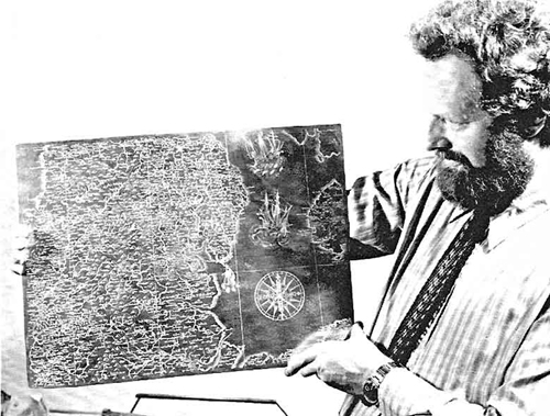 |
Once discarded, an engraved copper-plate would usually be melted down. Occasionally, it was painted over by an artist and thus preserved, as happened with this variant sheet for part of Saxton's wall-map of England and Wales.
|
Until recently the engraved surface of the plate was covered by an inferior, and damaged, seventeenth century Dutch school painting, which had helped to preserve it relatively undamaged. (By contrast the London plates were painted on the back.) The plate depicts northern England, with sections of the Isle of Man and North Wales, in a band between Carlisle and Newcastle on the one hand and Conway and Sheffield on the other. The visual similarities with the relevant sections of Saxton's wall-map of 1583, and their precise match of scale, pointed to the need for a thorough comparison of the two.
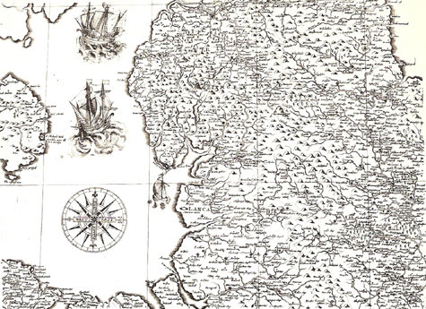

The immediate similarities between the modern impression taken off the copper-plate (left) and sheet VII of Saxton's wall-map of 1583 (right) are striking. Note, though, the use of English lettering on the copper-plate for the compass rose and county names. The copper-plate and the impression from it, by courtesy of Robert Douwma (Prints and Maps) Ltd. The map of 1583 - original in the Map Library, the British Library.
Saxton's wall-map, the first of its kind to be produced in England, is generally considered to be the work of the engraver Augustine Ryther, the man who had earlier put his name to five of the sheets in Saxton's atlas of 1579. As can be made out from the two surviving copies of the map in its original form (in the British Library and Birmingham Public Library respectively) the wall-map was composed of twenty sheets, arranged in five rows of four and each measuring 275 x 452mm. The Birmingham copy has in addition a separately printed heraldic border. The most noticeable difference between those sheets and the newly discovered copper-plate is the latter's much greater size, 398 x 527mm. This implies a map of twelve sheets, distributed in four rows of three, with the copper-plate representing the middle sheet of the second row. If it duplicated the overall dimensions of the surviving map the small space left above the copper-plate and the large area involved to its right might have been made up with half sheets and extra strips. The disparity in their sheet divisions has led to the copper-plate concerning itself with parts of no fewer than six of the 1583 sheets (no. 2, 3, 6, 7, 10 and 11).
Five years ago a facsimile was issued of the British Library's copy of Saxton's wall-map.1 The text prepared by R.A. Skelton with A.D. Baxter and S.T.M. Newman dealt in detail with all the known documents relating to the map. None of these throws any light on the copper-plate, whose existence had not previously been suspected. The authors also discussed the only identified imitations of Saxton's map: one prepared by Wenzel Hollar for Thomas Jenner (the Quartermaster Map); the other published in Amsterdam by Cornelis Danckerts. Both were issued in 1644. Each is quite distinct from the copper-plate: the first map [has] names found equally on the plate and on the 1583 map; the second uses Thomas Durham's improved outline for the Isle of Man, which had been engraved for Speed in 1605. The copper-plate does not incorporate, either, any of the revisions (roads, for example) made to the map of l583, probably after 1678. So what is the copper-plate? Is it part of a contemporary imitation of the wall-map, a later copy, or an abortive first attempt? The best way we can test these various hypotheses is by taking a close look at the place-names.
The most startling characteristic of the copper-plate is its use of English rather than Latin for the cardinal points and the large county lettering - Cumberland, Westmoreland and Lancashire. In this the plate differs both from the l583 map and its two derivatives. The city of Durham is also singled out in the form that Speed would use: Durham instead of the medieval spelling Duresme. Ignoring for the moment the absent headings for Durham and Yorkshire, the names missing along the outer edges, and the labelling of lesser rivers and lakes that seems to have been intentionally left off, the plate omits twenty-one of the names found on the l583 map. This is not in itself significant. It indicates careless copying, presumably, but does not pinpoint the particular model used. The thirty-nine clearly corrupt forms found on the plate, though, are a different matter. Where the map of 1583 and the relevant county sheets coincide in almost every case, the copper-plate's engraver commits several obvious errors. There is space to cite just a few.
|
Copper-plate |
Wall-map of 1583 |
Modern form |
|
Aalwaterterne |
Malwaterterne |
Malham Tarn |
|
Alher |
Alker |
Altcar |
|
Anlghton |
Aughton |
Aughton |
|
Beake |
Peake |
Peak |
|
Charleton |
Carleton |
Carleton |
|
Coron |
Corno |
Corney |
|
Eanley |
Emley |
Emley |
|
Edgermond |
Egremond |
Egremont |
|
Marrith |
Marrik |
Marrick |
|
Newell |
Bēwell |
Benwell |
|
Penmauer |
Pēmēmaure |
Penmaenmaur |
|
Secham |
Seham |
Seaham |
In many instances it needed only the omission, transposition or addition of a single letter for the name's pronunciation to be altered. Yet it is hard to see how this could have happened if the engraver had been following the only printed map available, the clearly lettered wall-map of 1583. If the plate was copied from a manuscript, though, it is easy to see how M could turn into A, how contraction markings might disappear and how some letters might be interchanged. Even more telling is the way that seven pairs of neighbouring villages have had their names transposed, a mistake easily made when trying to marry up a place-name and the village symbol on a crowded manuscript, but not when the only relevant engraved map shows them well separated and in their correct positions.
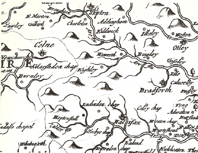

The area around Skipton illustrates the typical place-name differences between the copper-plate (left) and the map pf 1583 (right). The copper-plate omits Thornton, corrupts Carleton into Charleton and transposes Haworth and Keighley.
There are two other pieces of evidence. In the first place, some of the names not found on the copper-plate appear to have been added to the 1583 map as afterthoughts (like Muggleswick and Mitton), possibly even by a different engraver. In two of these cases there are no village symbols (Bergerode and Brodley); in two others there are signs of erasure (Stokesley and Heselwood)¬ - perhaps the name was difficult to read. Secondly, the 1583 map's own confusions - Downebam for Downham and the partly illegible Welbury - are handled correctly on the copper-plate. In the face of these various strands of evidence it is hard to see how the copper-plate's engraver could have been working from anything other than a manuscript. And is it likely that there was more than one hand-drawn version of Saxton's wall-map?
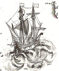
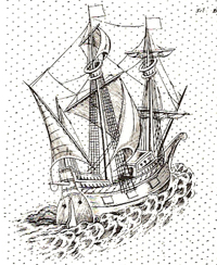
Comparison of the same ship on the copper-plate (left) and the wall-map of 1583 (right) shows minor variations in the rigging as well as quite different treatment of the waves.
Close examination of the two larger ships shows that the man who prepared the plate was seemingly as careless with nautical detail as he was with nomenclature {toponymy}. But he does insert a few tiny sections of rigging that are not found on the 1583 map (for example between the tops of the masts on the lower ship). The most likely explanation for this is that both engravers were working from the same original and that this was already equipped with its decorative detail. Whatever the nature of this manuscript it seems not to have been a simple reduction of those used in the compilation of the earlier and larger-scale county maps, as both forms of the wall-map include names not found on the county sheets. That the county map's Over Acaster is rendered incorrectly by the plate as Ouracaster and by the map of 1583 as Oi[l ?]a caster, spotlights, perhaps, one illegible word on the manuscript of the wall-map. Yet the unnecessary duplication of the symbol beside Millom Castle on all three reminds us of the ultimate common source, Saxton's own drafts.
The copper-plate deserves a more thorough analysis than time has yet allowed. Further attempts need to be made to identify the engraver responsible. His very slanted and broadly cut lettering is distinctive and not as yet traced elsewhere, while the etched treatment of the waves (possibly the work of another man) is handled far more dramatically than on the 1583 map.
We might propose, then, the following tentative reconstruction of the copper-plate's origin and purpose. On completion of the county atlas in 1579 Saxton, or more probably his paymaster Thomas Seckford, commissioned an engraver to prepare the wall-map. This individual was certainly not one of the seven who signed the county maps, nor can his hand be identified with confidence on any of the unsigned sheets in the atlas. But it has been noted that as the atlas progressed English engravers increasingly replaced the Flemings, whose more florid style had dominated the earlier stages. The plainer work on some of the unsigned sheets (particularly the latest ones) is noticeably closer to the copper-plate. Whether the plate is complete or not - and some of the absent features, like sea stippling and county names, might reasonably have been left to the end - it seems evident that it was never published; there is certainly no sign of printing wear. In this way it was presumably acquired by an artist as scrap copper, whereas the 1583 plates remained in the trade at least until 1795. Perhaps the engraver died and his style could not be matched by his successor, or his work might have been rejected. The delay that this would have caused to the project might help explain the four-year gap between the atlas and the wall-map. Presumably when the commission was transferred to Ryther the decision was taken to reduce the sheet size and abandon vernacular headings.
If the study of prototype maps consists essentially in an attempted reconstruction of the manuscripts on which they are based, the copper-plate and the equivalent sections of the 1583 map can perhaps be used in tandem to shed a little more light on the lost drafts of Saxton's survey.
Reference:
1. R.A. Skelton (with A.D. Baxter and S.T.M. Newman) edited by J.B. Harley, Saxton's survey of England and Wales. With a
facsimile of Saxton's wall-map of 1583 (Amsterdam: Nico Israel, 1974). [Issued as Supplement VI to Imago Mundi.]