

(main menu)
CAMPBELL
articles
SITEMAP
site is
ABOUT
NEW

|
|
(main menu) |
CAMPBELL articles |
|
SITEMAP |
site is ABOUT |
NEW |
|
The author, Map Librarian [now retired] of the British Library, was for twenty years a cataloguer in the antiquarian map business. He offers warning and advice to aspiring cartobibliographers, and indeed to any who wish to deepen their appreciation of engraved maps as physical objects.
The content of a printed map is, of course, of primary importance and interest. But, if the map is to be properly understood, it must first be considered as a physical object in its cartobibliographical context. For instance, unless a 1676 printing of a John Speed county map is seen as a reissue of one engraved in the l600s, and copied, with minor mistakes, from Christopher Saxton's survey in the 1570s, an account of the Elizabethan landscape will be mistaken for one of Restoration England. Reconstructing a lineage of that sort, for areas less fully studied than English county maps, can be partly achieved by delving into historical sources. Much more will emerge from examination of the maps themselves.
Accurate and adequate reconstructions of early map production techniques already exist, and this piece will not attempt to retrace the same ground.1 Nor will it trespass on the detailed technical accounts of expert practitioners.2 [See, for online examples, Web articles: themes (‘Printing methods’)]. But it is notoriously hard for those interested in recreating the publishing history of printed maps to find practical advice, and each has had to devise their own working methods. This article will try to pass on some hard-won personal experience gained during twenty-five years spent in close observation of early maps. Those who follow will no doubt adapt and improve on the suggested procedures. The best advice was given by the late Professor Coolie Verner some years ago.3 It will be impossible to avoid retracing some of his steps, but this opportunity to present the ‘nitty gritty’ of early maps to a wider audience, with the benefit of illustrations, is intended as a tribute to an inspiring example, and a friend.
The overwhelming majority of maps produced between the mid-sixteenth and mid-nineteenth centuries are engravings, normally on copper. But—when laying down what could be termed the first law of cartobibliography—it is not necessary at this point to distinguish engraving from woodcut and lithography, the two other techniques most likely to be encountered by those handling pre-1850 maps:
Each printed map is an impression made by the transfer of ink from a unique printing platform or group of platforms (usually woodblock, copper plate or lithographic stone).
No understanding of printed maps is possible unless this simple fact is kept constantly in mind. This is, in a sense, the copper-bottom-line of cartobibliography. Since it is hardly ever possible to examine the printing platform itself, and never in any but its finally amended form, the researcher must make do with surviving printed impressions taken from the particular platform concerned. Of course, it is primarily printed maps that are collected, curated and studied, not woodblocks or copper plates. But if we are to begin tapping the secrets of maps it is as well to remember the second law of cartobibliography:
The piece of paper we are looking at is no more than a reflection, literally a mirror-image, of a wooden, metal or stone printing platform, which was present in a particular workshop at a particular time.
The cartobibliographer's primary task is to recount the life history of a printing platform—the intentional and accidental changes made to it—by attempting to place in order a series of impressions pulled from it. He can then run out these maps in a numbered chronological sequence as ‘State 1’, ‘State 2’, etc.,4 because each state represents an irreversible amendment to the printing platform.5 This crucial point is often lost sight of in the literature and one sometimes reads of elements on a map disappearing and reappearing, in a manner no more plausible than that of Alice in Wonderland's Cheshire Cat.
I have used the ungainly term printing ‘platform’ so that comments could apply equally to woodblocks, copper plates and lithographic stones in a way that ‘plate’ cannot. The practical discussion that follows, however, will be concerned solely with copper engraving, an intaglio process in which the printed detail is cut into the plate. Woodcut is the opposite of this in that all unwanted matter is cut away (a relief process), whereas the lithograph is drawn directly onto and reproduced from a flat surface (planographic). Any examination of maps produced by one of these three different methods starts from premises that are inapplicable to the other two. Woodcut and lithography would need their own separate articles {Afterword: this was not done}.
The bibliographical method for dealing with engraved maps seems deceptively simple. Maps that are similar in appearance must first be sorted by PLATE and then by STATE. To determine if two similar maps are taken from the same or different plates it may be necessary to look very carefully at the finest detail. It was common publishing practice to make faithful copies of the work of others. Indeed, the copyist would often take a rival publisher's map and transfer the outline directly to the new plate, re-engraving exactly along the old printed lines.6 Such an imitation will inevitably look identical to its model.
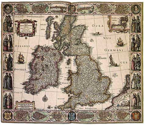
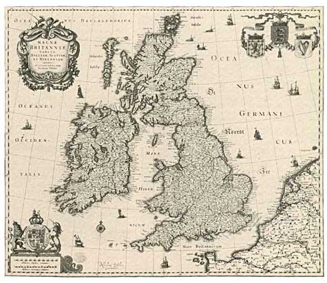
The map of the British Isles was dramatically transformed between its original printing (left) by Claes Jansz. Visscher about 1623 and its reissue (right) by his son Nicolaes perhaps 50 years later. Note the unchanged North Sea lettering. This is a good example of the trouble a publisher would take to preserve an existing copper plate (by courtesy of the British Library, Maps C.3.c.9 and K. Top. 5.5).
Precise measurements will not necessarily reveal the separate origin of two apparently indistinguishable maps. Paper was dampened before printing and would shrink afterwards. Hence a printed map is always slightly smaller than the plate it is printed from, and copies may be a little smaller than their models.
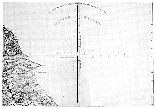
Aaron Arrowsmith's ‘Scales shewing the unequal shrinkage of paper’ (plate 6 of his map of England and Wales, 1815) explains how dampened paper shrinks after printing. According to his figures, it worked out at 0.9% vertically and 1.3% horizontally (By courtesy of the British Library, K. Top, 5.74. 11 TAB).
Nevertheless, as the rate of shrinkage is unpredictable, it is unwise to place too much reliance on measurement to identify a copy because there can be great differences between impressions taken from the same plate (what we shall call sibling impressions).7 It is possible, however, to compare the blank band between the printed image and the plate-mark (the recessed line that marks the edge of the copper plate) since significant variation here could well reveal different plates or even modern imitations.
A better way to tell whether one or more plates is involved is to look at fine detail, and in particular at lettering. The way words are broken up by the lines of longitude and latitude, for instance, can often be revealing [compare the last two detail views of the Ortelius map of America, see below]. Another method (and one used in various bibliographic disciplines) is to place a ruler diagonally across inscriptions on two similar maps, noting whether it lies across the same letters. Whereas other detail would be directly transferred to a new plate, lettering often seems to have been copied by eye. The second engraver was not trying to deceive a twentieth- century cartobibliographer by making a strictly accurate copy (however much one might suspect it) and small differences between two plates can usually be spotted.
If the tests outlined above suggest that a single plate is involved, or if the issue is unresolved, the way to demonstrate this beyond doubt is to identify shared accidentals. No engraver ever copied another’s slips of the graver, for instance the overrunning of a line, nor will the new plate repeat damage on the original. Duplicated scratch marks are the best proof that two maps are sibling impressions. In some cases, evidence of this kind is the only way to show that dramatically differing maps originated from the same plate.
Assuming that a number of similar maps have been divided into groups according to the unique plates that produced them, the next stage is to order each group of sibling impressions into a confident sequence of states. The distinction between ‘plate’ and ‘state’ cannot be emphasised too strongly. Whatever the apparent similarities between two maps from different plates, no single feature can be assumed to be identical on both. Every line, every single letter, would have to be checked before the maps could justly be described as indistinguishable in content. Given the immense amount of detail on an average map, and the hundreds of place-names involved, it is inevitable that there will be small discrepancies at least. To identify these might take many hours, yet a single omission, duplication or corruption could be vital in determining whether the later plate had followed the original map or a copy of it.
When dealing with maps pulled from different plates nothing is the same until proved to be so. States from a single plate, on the other hand, will be identical except where intentional alteration or accidental damage has taken place. The process of turning sibling impressions into a defined sequence of states consists, therefore, in observing and interpreting the changes that occurred during the life of a single plate.
Changes to a plate are made once and for all. This fact must never be forgotten. It is possible that a map dedicated to the Earl of A and subsequently altered to honour the Duke of B might, in its third state, repeat the dedication to the Earl of A. Highly improbable, but theoretically possible. In that instance, however, the second dedication to the Earl of A would have been freshly cut over the erased inscription honouring the Duke of B, itself a replacement for the original dedication. Adding the second dedication, like any other plate change, would have involved hammering the plate from behind and rubbing the relevant part of the engraved surface until the soft copper spread out and obliterated the incised lines. The erasure and the new engraving are equally irreversible steps; thus comparison of our two hypothetical dedications to the Earl of A would reveal differences in the engraving.
There is therefore only one possible printing sequence for a group of sibling impressions. By contrast, similar, even ‘virtually identical’ maps pulled from different plates can only be placed in chronological order after some thought, and the conclusion may be open to challenge. Was this particular mistake perpetrated by the engraver of plate A and corrected on B, or is plate A actually a later and corrupted form?
Running out a group of sibling impressions into an unchallengeable chronological sequence is usually an easy task, even if none of the printing dates is known. Conspicuous additions or deletions will often allow the impressions to be subdivided into an earlier group without the change and a later one with it. Tell-tale traces of imperfectly erased matter will often give the game away.
If the bibliographer intends to document every change, one method is to make a minute comparison of the earliest and latest impressions. Once all the differences between them have been noted, the intermediate impressions can then be checked in turn against the list of changes, and the first occurrence of each alteration noted. Every subsequent impression will automatically repeat the alteration in question, unless that section of the plate was later reworked. The only drawback to this method is that if a place-name was added in State 2 and removed in the penultimate state, it would not show up in the analysis.8 This rarely occurs and the saving of time and effort is so great that most researchers would find it an acceptable alternative to a minute, side-by-side comparison of each state with its successor.
In practice, there will be few people with the necessary time or commitment for even a full comparison of first and last states. Others will seek short-cuts and it is possible to provide these on the basis of known probabilities. It is useful to consider first the types of plate changes, largely as identified by Verner.9
Except for the last category, all these involve intervention on the part of those who had access to the plate in question. This prompts what we shall dub the third law of cartobibliography:
To understand early printed maps, first try and enter the minds of their authors or producers.
Since it costs money to alter a plate, the publishers of early maps tended to undertake this as infrequently as possible, and then only because it made commercial sense. Researchers often forget that each engraved map represented to its publisher an equation in which costs (copper plate, engraver's fee, presswork expenses, paper, etc.) had to balance sales to produce a profit. With some notable exceptions (including, of course, official survey departments) map publishers were businessmen first and geographical scholars second, if at all.
Our first category, geographical change, must theoretically consider the possibility that any single feature might have been altered during the course of a map's life. The third law of cartobibliography, on the other hand, reduces this nightmarish possibility to manageable proportions. Many who look at early maps start with the assumption that map publishers would have access to the latest geographical information and would automatically incorporate it into their maps without delay. In fact, this seldom happened.
If a publisher is known to have belonged to the ‘laissez-faire’ majority, and if a check shows that he failed to react to major changes, it is unlikely that other geographical features would have been altered either. However, ‘major’ when seen from mid-eighteenth century Spain, for example, might well not square with what seems important in another country today. A publisher would respond to his own public, who were likely to have rated highly those events that enhanced their country’s prestige. Universal talking-points would be looked for on maps and there was doubtless pressure from customers to provide them; other features could often be safely ignored. Hence the discovery of the Cape Horn passage in 1616 and the foundation of Philadelphia in 1682 were cartographic ‘musts’ whereas, surprisingly perhaps, the Dutch charting of Australia and the foundation of New York were cartographic non-events.
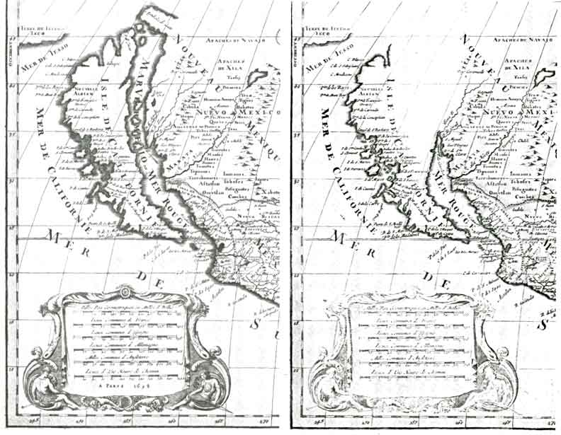
The California-as-an-Island misconception, prevalent through most of the 17th century, died out during the first part of the 18th. However, when A. H. Jaillot's map of North America (1694) was reissued by J. B. Elwe (1792) California's shape had been altered, but not its label. No hint is given of a now-independent United States, nor is there mention of Boston, capital of Massachusetts since 1632 (By courtesy of the British Library, Maps C.39.f.12 and Maps C.40.f.7).
The second category, mathematical change, tends to involve genuine improvement of a technical nature, and is seldom encountered.
Once the commercial imperatives underpinning a publisher's attitude to his plate stock are taken fully into account, it will come as no surprise that most states of an engraved plate are defined in terms of the third category, bibliographical change. The most common alterations to a printed map concern either the date or the publisher's name and address. The popular formula, ‘A new and correct map of …’, sometimes used to mask a copy of a copy made some decades before, indicated a publisher's desire to pass off his productions as topical. A similar effect would be achieved by altering the date, and nothing else. Since it was the year that mattered, day and month would often remain untouched.10

When John Jefferys engraved his map of the roads of England and Wales in the 1750s, he left off the last two digits of the date. These were inserted in ink, presumably at the point of sale. Close examination of early maps with this possibility in mind will probably reveal many other instances (By courtesy of the British Library).
Leaving a map undated in the first place avoided this problem, which is why such a large proportion of early maps were mute on this point. Ironically, those responsible for modern imitations frequently add a date to give supposed authenticity.
A map's imprint provided free publicity for the publisher. When combined with his address, it directed the potential customer to his shop. Map plates frequently passed from one publisher's possession to another, and publishers often moved premises. It is rare to find a map that is reticent about changes of this sort. Maps are therefore a good source of commercial information about their creators. However, care must be taken not to give credence to an address found linked to an anachronistic date. Guillaume Delisle, Aaron and John Arrowsmith, to give just three examples, left the dates on their maps unaltered as they recorded moves to a succession of new premises.
Decorative change, the fourth type, is likely to concern highly visible elements of a map and hence be easy to identify. Even when it is tempting to see aesthetic alteration as evidence of creativity, a commercial motive is sometimes more plausible. The reason that Mercator's maps were restyled in the 1630s was to hide their sixteenth-century origin. Although portraits, particularly of royalty, served far more than a decorative function, they can be mentioned at this stage as one of the elements a map publisher would feel the greatest need to change.
The fifth category of change we have termed ‘maintenance’. This primarily involves the recutting of engraved detail. Repeated subjection of the relatively soft copper plate to the great pressure of the rolling press imperceptibly wore it down and reduced the depth of the original cut, so that it was able to retain and transfer to the sheet of paper progressively less ink. Opinions vary as to the number of impressions that could be taken from an unretouched copper plate, but it was probably in the middle hundreds.11 Some publishers clearly arranged for their plates to be recut before the reduction in quality became noticeable—you never find a faint Blaeu map, for example. But others, and J. B. Homann is a good instance, continued to pull, and sell, maps that by the end were no more than semi-legible. Recutting could affect small details, or specific categories of engraving, or the entire plate. The topographical detail on Emanuel Bowen’s largest map of Sussex (1749) was recut, for example, while less essential elements such as the title cartouche and plan of Lewes were allowed to fade into obscurity.
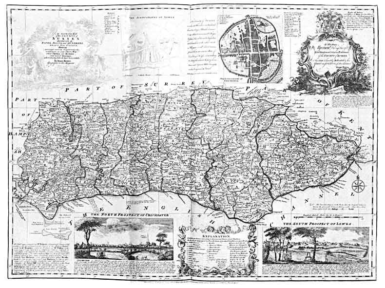
Emanuel Bowen's largest map of Sussex was first issued in 1749. By 1787, although the plate had been recut, the title and plan of Lewes had been allowed to fade into oblivion (By courtesy of the British Library, Maps C.10.d.17).
Recutting, a less skilled operation than the original engraving, is not likely to have been entrusted to highly-paid craftsmen. Given, additionally, that many of the finer lines would have disappeared before the publisher authorised the operation, a recut plate is inevitably less fine than its original form. The researcher is liable to be misled on two counts when faced with a revitalised plate. Firstly, the reincised lines may literally be new ones, if the original detail—coastal shading, for example—had become so faint that it was easier to start afresh. Even where the graver was following and enlarging the cuts of the first engraver, the new craftsman might well impose his own forms on some letters. Secondly, it is confusing that successive states which had been getting progressively weaker should be succeeded by one that might be even blacker than the earliest printing.12
The alternative to recutting was to engrave a new, substitute plate. These replicated plates are sometimes hard to distinguish from the originals. Whereas some publishers favoured either recutting or plate replication, others employed both methods. It is now becoming clear that the Ortelius and Homann maps were kept alive at different times in both these ways.13 Careful analysis will be needed before we can be sure just how many of their maps were affected and in what ways.
From time to time, plates were cut down by the publisher. Suggestions that a plate might have been extended are implausible, given that it was probably impossible to attach an extra section to a plate in such a way that it could withstand the immense pressure of printing. Plates butted together for combined printing (at least in the period before electrotyping and lithographic transfer) will betray their separate plate-marks. But trimming off a section from a plate was quite a common occurrence, particularly around 1630 when the ornate maps of Willem Blaeu and his rivals surrendered their borders so that they might fit the format of a standard atlas.
Although repair to a broken plate belongs strictly in the maintenance category, this is more conveniently considered in the sixth and final category of plate change—accidental damage. Mistakes by the engraver have already been mentioned as the best way of building up a unique ‘signature’ for a plate. Other ‘accidentals’ may develop during the life of the plate.
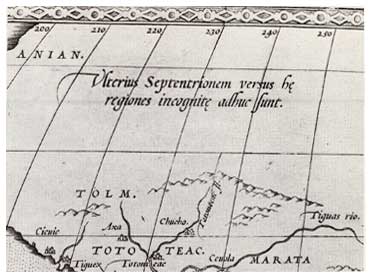
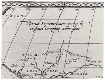
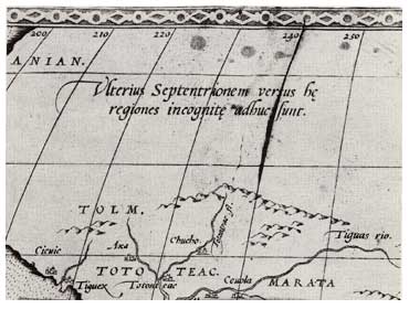
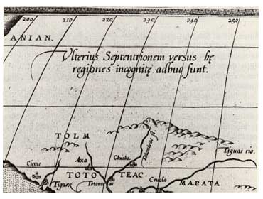
Three details from the unknown north-west on Ortelius's map of America (1570) show (above left) cracks beginning along the 230 degree meridian and the Tototeac river (1573), (above right) the cracks deepening (1574), and (below left) a new crack along the 240 meridian caused by attempts to burnish out the earlier splits. ‘Tototeac fl.’ has also been re-engraved (1575). (lower right) is the equivalent detail from the closely copied plate of 1579. Note how the 230 degree meridian now passes between the ‘g’ and ‘n’ of ‘incognitae’ (1584). (By courtesy of the British Library, Maps C.2.c.9; Maps C.2.c.11; 9 TAB 10; Maps C.2.c.18).
Damage could take various forms, the most common being scratches and breaks. Whether these developments should be considered as ‘states’, in the same way as acts of conscious human intervention, is for others to decide. Nevertheless, they can confirm, and sometimes refine, a sequence of states. Whereas scratches will become fainter with time since they react like the engraved image, breaks tend to deepen. On occasions, rivets would be inserted in an attempt to hold the plate together. If the weakness occurred at the edge of the plate, as with the Speed map of Surrey, the entire corner might be lost. Such accidents can provide a watershed in the printing history of a particular plate. All impressions of the Speed map of Surrey with the missing corner, for example, must be later than 1627.
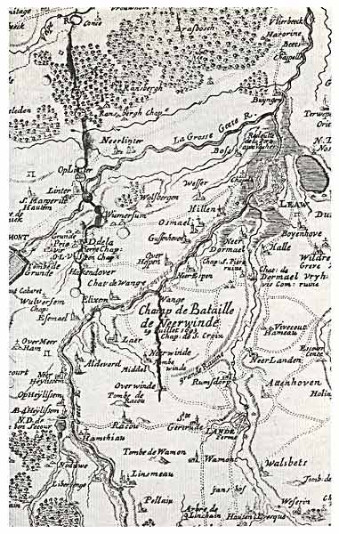
The circular rivets can be clearly seen along a vertical crack running down this detail from the Louvain sheet of E. H. Fricx's ‘Carte generale des Pays Bas’ (1712). It is a late printing, somewhat after the 1744 date it bears. Another split through the battlefield of Neerwinden looks in need of the same treatment (By courtesy of the British Library).
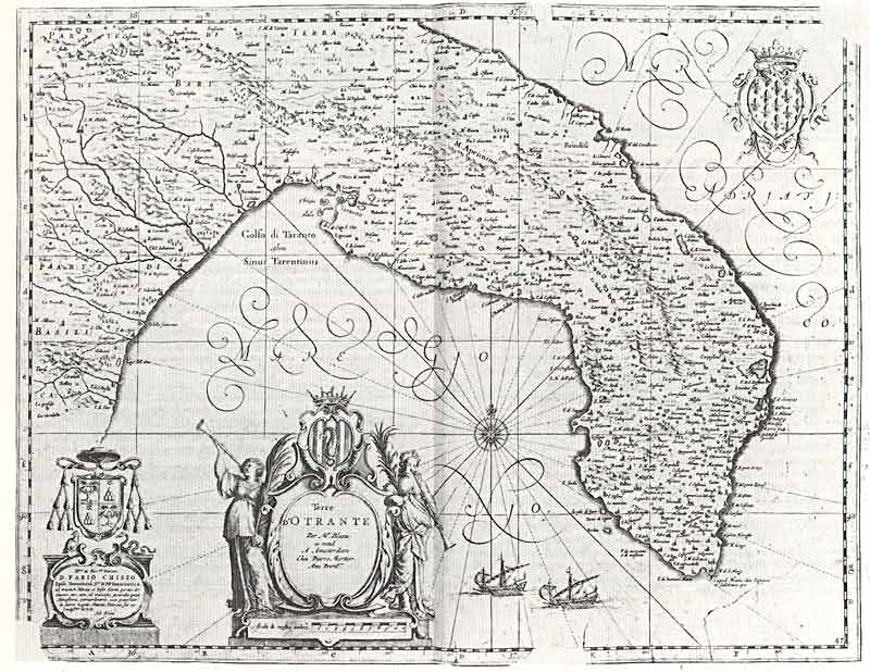
The Otranto sheet from Pierre Mortier's town book of Italy (1705) is a Blaeu plate originally published in 1640. The splits and sizeable missing sections around the edge demonstrate both how a plate could become damaged with use and how a brazen publisher would ignore such defects (By courtesy of the British Library, Maps C.25.d.12).
For analytical convenience, changes to engraved maps have been marshalled into six categories. It is best, though, if plate histories ignore these divisions. What is needed for each succeeding state is a clear statement of those ways in which it differs from its predecessor. Reference to common or repeated elements should be ignored, since this is superfluous.
To underline the extent that the printed sheet serves as a surrogate for the absent (and almost certainly destroyed) plate, the sequence of states will sometimes include theoretical variants. Actual impressions do not always have to be traced before prior or intermediate states can be identified with some confidence. Once the chronological order of states has been established, gaps may be apparent. The evidence for hypothetical states comes largely from inscriptions, which, though supposedly erased, remain partially legible. Close examination of an apparently unrecorded ‘anonymous’ map of America, recently acquired by the British Library, allows the erased imprint of the mid-eighteenth century London publisher, George Foster, to be resurrected, thus adding two, rather than just one map to the appropriate bibliographies.14
There is no statement of responsibility on ‘A new & correct map of all America … 1763’. Or is there? An erased inscription at the foot of the sheet can just be made out, revealing the following: ‘Printed and sold by Geo. Foster at the White Horse opposite the north gate in St. Pauls Church Yard London’. This allows Foster's small recorded map output to be increased by one (By courtesy of the British Library, Maps CC.5.a.262).
This brief introduction has highlighted some of the snares waiting to trap the unwary researcher, in the hope that its relatively simple prescriptions and outlined shortcuts will encourage others to tackle cartobibliography. There are maps of many parts of the world waiting to be described; a good eye and copious dedication are the main qualifications needed.
![]()